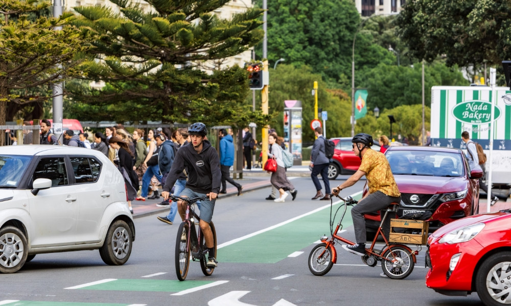
Bunny Street connection
Wellington City Council is progressing improvements to the northern end of Lady Elizabeth Lane and Bunny Street to complete a critical missing walking and cycling connection between the new Thorndon Quay cycleway, the Hutt Valley, the waterfront, and central city destinations.
The project will provide a safer, more direct, and more comfortable route for people walking, biking, and scooting, while improving access through one of Wellington's busiest transport gateways.
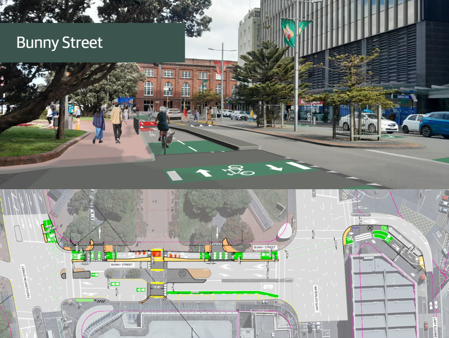
The improvements respond to the expected growth in cycling following the opening of Te Ara Tupua and the completion of major cycle routes from the south, west, and north. They also address an existing gap in the network, where people travelling by bike currently have no clear or safe connection between Lady Elizabeth Lane, Bunny Street, and Waterloo Quay.
The project is also informed by the area's safety record. Bunny Street has recorded 61 crashes over the past decade, including incidents involving people walking and cycling, highlighting the need for infrastructure that improves safety for all road users.
Proposed changes
The proposed changes for Bunny Street and the northern end of Lady Elizabeth Lane include:
- Improving pedestrian safety and crossings between Wellington Railway Station and surrounding destinations.
- A raised mid-block crossing to improve safety and accessibility for people travelling to and from Wellington Railway Station, while helping to slow traffic in this busy pedestrian area.
- Installing a separated two-way cycleway on the northern side of Bunny Street, between Featherston Street and Waterloo Quay.
- Removing six P120 metered parking spaces from the northern side of Bunny Street.
- Making the west side of Bunny Street one-way for vehicles between Lambton Quay and Featherston Street (cycles can continue in both directions). Vehicles will exit via Lambton Quay.
- Installing a 42-metre cycle lane on the northern side of Lady Elizabeth Lane near the Waterloo Quay intersection.
- Reducing the number of turning lanes at the Bunny Street/Waterloo Quay intersection from three to two: one right-turn lane and one shared left/right-turn lane.
- Shortening the coach stop by 7.5 metres to improve visibility around the mid-block crossing.
Why is the Bunny Street connection needed?
The Bunny Street connection will:
- Broaden transport options in and around the city centre, making it easier to walk, cycle, scoot and use public transport.
- Connect the Thorndon Quay cycleway with the waterfront and central city destinations.
- Support the growing number of people cycling into and around Wellington.
- Improve safety and accessibility for people walking to and from Wellington Station.
Why now?
Cycling routes into the CBD from the south, north and west are now complete, with the Evans Bay route from the east expected to be completed this year. As these connections come online, more people are expected to cycle into and around the city.
Te Ara Tupua is also expected to significantly increase the number of people cycling between the Hutt Valley and Wellington, with cycling trips forecast to more than double in the first year and more than triple by 2030. The Bunny Street connection will help accommodate this growth by providing a safer, more direct link between the Thorndon Quay cycleway, the waterfront and central city destinations.
Changes for different users
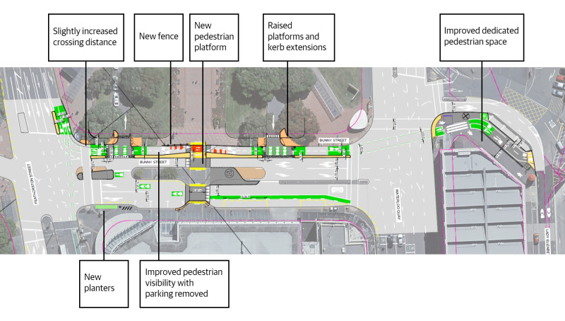
Proposed changes to improve pedestrian safety and accessibility:
Safer crossings
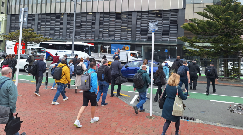
- An improved pedestrian crossing across Waterloo Quay will improve safety and visibility for people walking, and separation from bicycles.
- A wide raised platform in the middle of Bunny Street will support safer and more accessible pedestrian movement while helping to slow vehicle speeds.
- Raised platforms and kerb extensions at the Wellington Station drop-off loop entry and exit will improve pedestrian crossings, slow traffic and shorten crossing distances.
- The pedestrian crossing at the Featherston Street end of Bunny Street will be lengthened by approximately 1.2 metres to accommodate new cycle turning lanes.
More space and fewer conflicts
- The Waterloo Quay crossing will create a clearer pedestrian-only space where it connects with Lady Elizabeth Lane. The new cycleway will move people cycling out of the pedestrian area, reducing potential conflicts.
- Additional pedestrian space will be provided on the Lady Elizabeth Lane side of the Waterloo Quay crossing, improving visibility at the building corner pinch point and reducing crowding during peak periods.
- Six on-street parking spaces outside Wellington Station on Bunny Street will be removed to improve visibility of pedestrians.
Improved pedestrian environment
- A wider footpath will help keep crossing points at the station entrances clear of parked vehicles.
- Additional fencing and planters at the corner of Featherston Street and Bunny Street will encourage more predictable pedestrian movements and discourage informal crossing.
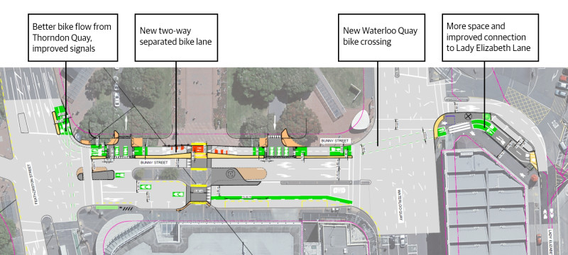
Proposed changes to improve cycling connections:
New cycling infrastructure
- Install a separated two-way cycleway along the northern side of Bunny Street, connecting Thorndon Quay with the Waterloo Quay crossing.
- Install a dedicated bicycle signal for people travelling west along Bunny Street towards Featherston Street.
- Provide dedicated turning and straight-through cycle lanes at the Thorndon Quay/Bunny Street intersection.
Safer and more direct connections
- Improve safety and provide a more direct connection for people cycling and scooting between Thorndon Quay and Waterloo Quay.
- Improve the clarity and consistency of cycle crossing points at Waterloo Quay in both directions.
- Increase bike flow from Thorndon Quay into Bunny Street, with people cycling able to turn into Bunny Street at all times except during the pedestrian crossing phase.
Network benefits
- Deliver a key link in Wellington’s cycling network, connecting northern routes with the central city and waterfront.
- Support the expected continued increase in people cycling following the opening of Te Ara Tupua and other cycleways.
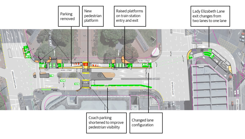
Proposed changes:
Safer driving environment
- Drivers will need to slow down when approaching the new raised pedestrian crossing on Bunny Street, supporting safer vehicle speeds.
- Drivers entering and exiting the station pick-up and drop-off area, including taxis and rideshare vehicles, will need to slow at the raised platforms and check for people cycling.
- The removal of parking outside the railway station on Bunny Street will improve visibility of pedestrians waiting to cross.
- Separated cycle facilities will make bike movements more predictable, helping drivers know where to expect people cycling.
Changes to road layout
- The lane layout at the Bunny Street/Waterloo Quay intersection will change from two right-turn lanes and one left-turn lane to one right-turn lane and one shared left-and-right-turn lane.
- These changes may result in minor queuing at times, and some drivers may choose alternative routes to access Waterloo Quay or the Quays.
Station access and coach parking
- There are no changes to taxi and rideshare pick-up and drop-off spaces in the station forecourt.
- The coach parking area will be shortened to improve visibility of pedestrians using the mid-block crossing.
The map below shows all public available parking, and the different types, within about 180 metres of Bunny Street.
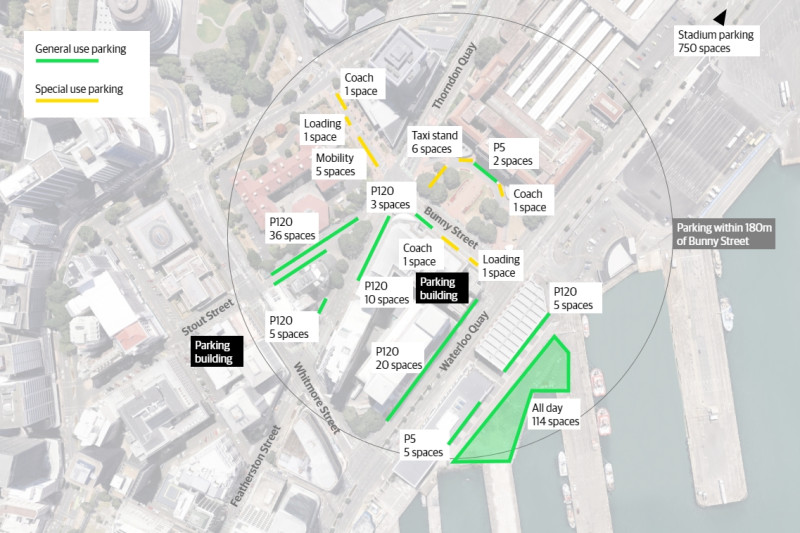
As part of our early engagement, we worked closely with groups in the community and stakeholders to hear their views and refine the proposed designs.
These groups included:
- Fire and Emergency NZ
- Local businesses along the Street
- Centreport
- KiwiRail
- Taxi company representatives
- Shed21 Apartments
- Cycle Wellington
- Bluebridge
- Flamingo
- Cycle Wellington
- Living Streets Aotearoa
- Victoria University
The crash history of this street illustrates that making improvements will create safety benefits for all users:
- Bunny Street has recorded 61 crashes in the past ten years, with 16% involving people on bikes and 10% involving pedestrians.
- These include 6 cyclist–car crashes, 1 cyclist–pedestrian crash, and 3 cyclist-only incidents.
- Pedestrian safety issues are evident in 8 pedestrian–car crashes and 1 pedestrian-only incident.
- Motor vehicle conflicts dominate overall crash numbers, with 41 private vehicle incidents, 2 car–bus crashes, and 4 motorcycle or moped–car crashes.