These street changes are now complete, making it safer and easier to walk, catch the bus, ride a bike, or scooter. You can read more about the Kilbirnie connections street changes on these pages. For questions or comments, you can find the Council's contact details here.

He tāone e hāngai ana ki te anamata
A city fit for the future
Kilbirnie and surrounding suburbs are growing and becoming increasingly popular places to visit. To support this growth, we’re changing to a more sustainable transport system that will reduce harmful emissions and give residents and visitors better options for how they get around.
The most important connections
Kilbirnie is a hub of activity for residents and visitors alike; including the bustling Kilbirnie shops, Lyall Bay beach, places of worship, daycare centres, and schools. It's a centre of recreational activity, with sportsfields, Kilbirnie Park, Ruth Gotlieb Library, Ākau Tangi Sports Centre (formerly ASB); and connects across Cobham Drive to Tahitai - the waterfront pathways that connect to the city and Te Motu Kairangi Miramar Peninsula.
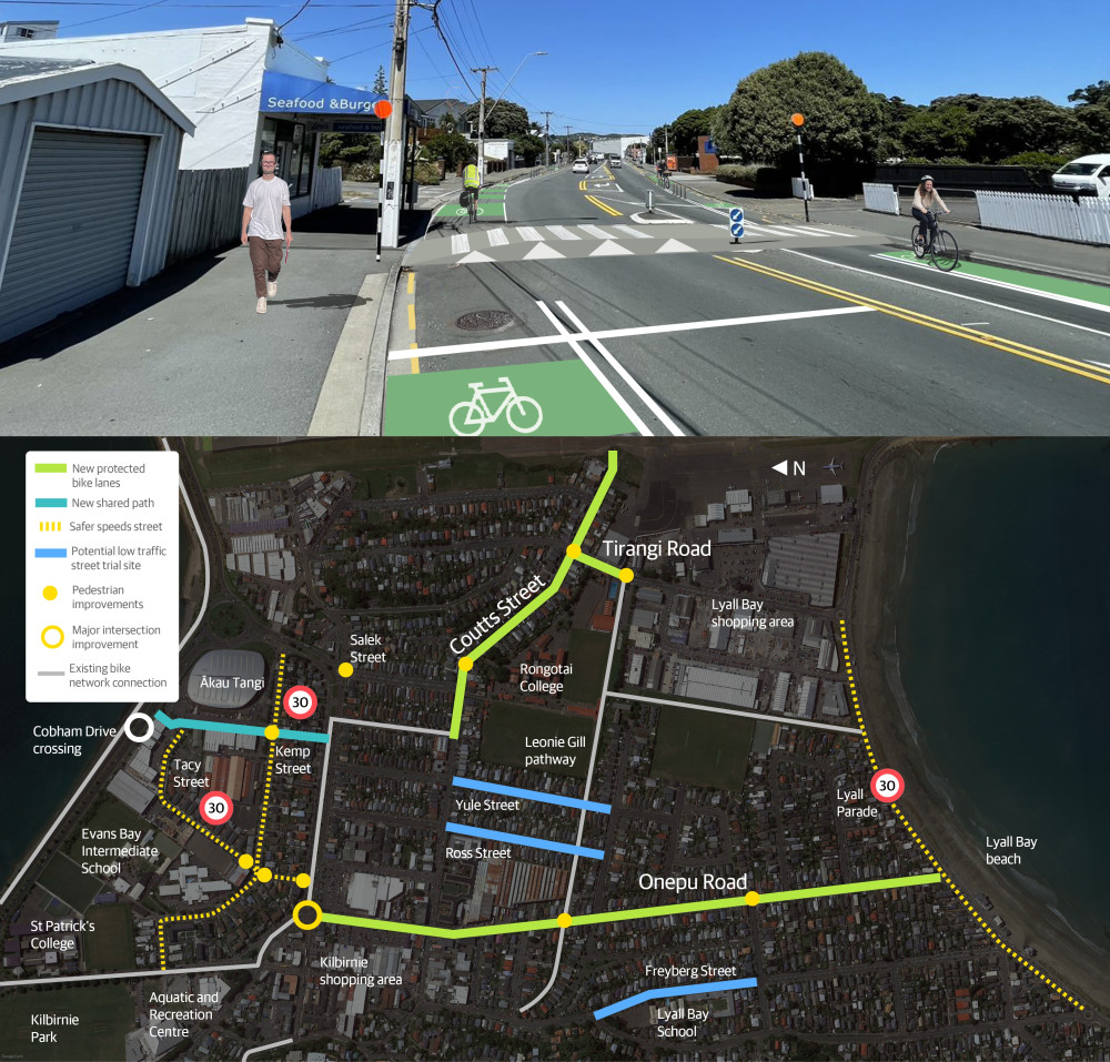
To make it easier for more people to use low carbon transport options to get to, around and through Kilbirnie, and make it a nicer place to visit and live, we used a mix of adaptable and more permanent materials to install:
- New and improved pedestrian crossings
- New separated bike lanes
- New 30km/h safer speed zone and other changes to encourage safer speeds in Tacy Street, Kemp Street and Lyall Parade
- A new shared path alongside Ākau Tangi Sports Centre car park
- Changes to bus stops on Onepu Road to improve safety and make bus trips quicker
- Turning restrictions for drivers at some side streets
- Removing some on-street parking in the area - see parking changes for full details
- A short-term trial of a low traffic neighbourhood on Freyberg Street
The new bike routes in this area have filled gaps in the Kilbirnie network, complementing and better connecting the bike paths and lanes that were already in place. The streets where changes have been made had earlier been confirmed as part of the strategic bike network in this area.
Changes in response to community feedback
From mid-2022, we began engaging with residents and businesses about planned improvements for people walking, biking or using buses in these streets. These discussions led to numerous changes in the proposed designs we took to the public for consultation.
Following community feedback through this formal consultation, we took our original proposal along with further changes to Koata Hātepe, Council's Regulatory Process Committee, for a decision.
The changes we made to the original proposal as a result of community feedback include:
- changing from proposed separated bike lanes to painted buffered bike lanes on Onepu Road between Wha Street and Lyall Parade, retaining over 50 car parks
- keeping bus stop 6327 in its current location and modifying it to improve accessibility, rather than the proposed relocation outside the Salvation Army
- proceeding to trial low-traffic changes in just one location at this stage - Freyberg Street between Wha Street and Queens Drive.
We first consulted on routes in Kilbirnie in 2018 as part of a wider eastern connections project. Several routes were completed following that consultation including Crawford Road, the Kilbirnie end of Evans Bay Parade, Rongotai Road, and Te Whiti Street.
Paneke Pōneke, Wellington's bike network plan, identified the routes that would fill the gaps in the Kilbirnie network, and better connect the bike paths and lanes that were already in place.
From 2022, we've worked with groups in the community and wider stakeholders to design the improvements along the route. We made changes in response to feedback from the community on the preliminary designs. For full plans, artist impressions, parking impacts and more, see the project details.
We took the proposed plans and community feedback through a traffic resolution consultation. Koata Hātepe, Council's Regulatory Processes Committee, approved the street changes for Kilbirnie connections on Thursday 11 May. This included changes made to the original proposal as a result of community feedback. You can watch the meeting and find the minutes from this meeting on the Council website.
Work to install the changes began in late July 2023 and is complete in most areas. The major upgrade of the intersection of Rongotai Road, Onepu Road and Evans Bay Parade is continuing. Later in 2024, as improvements at this intersection and the intersection of Onepu Road and Coutts Street are completed, we'll finish the bike connection along Onepu Road. Work south of the bus barns is complete.
As part of our early engagement, we worked closely with groups in the community and stakeholders to make changes to the original proposed design.
These groups included:
- Bus services
- Cycle Wellington
- Greater Wellington Regional Council
- Kilbirnie BID (business improvement district)
- Kilbirnie/Lyall Bay/Rongotai residents group
- Let’s Get Wellington Moving
- Living Streets Aotearoa
- Local businesses
- Local Police
- Local schools
- Rita Angus retirement village
- Supermarkets
- Waka Kotahi NZ Transport Agency.

What we heard: Kilbirnie Connections Proposal
This document summaries feedback received from the community about the project during the March 2023 consultation period. This report was presented to Council, along with all submissions in full when they were making the decision to proceed to installation.