The content on this page was accurate at the time of the traffic resolution consultation, and some changes were made to the project as a result of community feedback. We've kept this page to make sure we are being transparent about our process and to show how the project has developed. The main project page is the most up to date place, and more information about the Council's decision can be found in the meeting minutes. 

He tāone e hāngai ana ki te anamata
Preparing for the future – more options for more people

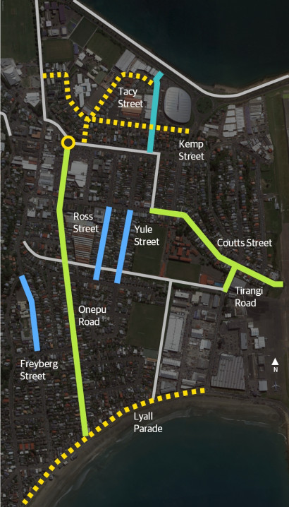
The changes along these streets will make it safer and easier to walk, scoot, bike or catch the bus.

Changes at a glance

The connections2x

The connections

  • New and improved pedestrian and bike crossings 
  • New separated bike lanes
  • New 30km/h safer speed zone and other changes to encourage safer speeds in Tacy Street, Kemp Street and Lyall Parade
  • A new shared path alongside Ākau Tangi Sports Centre car park
  • Changes to bus stops on Onepu Road to improve safety and make bus trips quicker
  • Turning restrictions for drivers at some side streets and supermarkets
  • Removing some on-street parking in the area - see parking changes for full details
  • Possible short-term trials of low traffic neighbourhoods in parts of Ross, Yule or Freyberg streets.

Changes planned in the Kilbirnie area have been designed to complement the upgrade of the intersection of Onepu Road, Rongotai Road and Evans Bay Parade, which is due to start later this year.

See the impacts in more detail for each section:

1 / 5

Walking2x Walking render2x

Changes for people walking

  • New 30km/h safer speed zones in Tacy Street, Lyall Parade and Kemp Street
  • Lots more safe places to cross including raising some existing crossings, new bike and walking crossings and some safer crossing points
  • A new shared path alongside Ākau Tangi Sports Centre car park
  • A short section of shared path at Coutts Street roundabout
  • Widen and improve the off-road shared path that links Kemp Street and Rongotai Road
  • New sections of footpath at the end of Tacy Street near the Cobham Drive crossing, and also near the airport underpass in Coutts Street
  • Changes to the footpath area outside Rita Angus on Coutts Street to stop cars parking on the footpath, and create clear separate pedestrian and bike spaces
  • Cruickshank Street would be quieter and safer due to vehicle entry/exit changes
  • Possible short-term trials in parts of Yule, Ross or Freyberg streets that would make them safer and quieter for people walking.

2 / 5

Bike2x Bike render2x

Changes for people on bikes

  • Creating a good connection for people walking and biking from the Cobham Drive crossing through to Rongotai Road by connecting the existing shared path with a new shared path alongside Ākau Tangi Sports Centre and a safer new crossing point on Kemp Street
  • More bike parking near the netball courts on Tacy Street, and on Lyall Parade
  • New 30km/h safer speed zone on Tacy Street, Kemp Street, and on Lyall Parade from Tirangi Road to Queens Drive
  • New raised bike and walking crossings at:
    • Tirangi Road at Leonie Gill pathway
    • near Coutts Street roundabout
    • Onepu Road at Leonie Gill pathway
    • Tacy Street at Kemp Street intersection
  • Separated bike lanes on both sides of:
    • Onepu Road between Rongotai Road and Wha Street
    • Coutts Street between Te Whiti Street and Tirangi Road roundabout, improving the route to the airport underpass
    • Tirangi Road between Coutts Street roundabout and Leonie Gill pathway
  • A short section of shared bus/bike lane near the bus barn entrance
  • Painted bike lanes on both sides of Onepu Road between Wha Street and Lyall Parade (this is an alteration to the original proposal made in response to community feedback and means about 50 car parks will be retained on this section)
  • New raised platforms at three bus stops on Onepu Road to improve bus access to the kerb and reduce conflict between people on bikes and vehicles
  • The option at Coutts Street roundabout to either share the traffic lane or use new crossings and a planned new section of shared path
  • Painted bike lanes with a 0.8m buffer on Coutts Street between the roundabout and airport underpass.

3 / 5

Bus2x Bus render2x

Changes for people using the bus

Onepu Road is the only place with removal and changes to some bus stops to allow for the new bike lanes and help make bus journeys slightly faster.

  • Retain stop 6327 in its existing location but with minor alterations to improve accessibility (in response to community feedback the proposal to move this bus stop slightly north to outside the Salvation Army Family Store will not go ahead)
  • Install a new raised bus stop platform at stop 7327 outside Harbour City Funeral Home (buses will stop in the traffic lane)
  • Remove two southbound stops:
    • Bus stop 6329 (near Resolution Street)
    • Bus stop 6331 (near the south end of Apu Crescent)
  • Move northbound stop 7328 to just north of Endeavour Street, and southbound stop 6328 10m south to improve visibility and space between stops
  • Move stop 7330 (at Onepu/Wha Street shops) slightly south and install a new raised bus stop platform (buses will stop in the traffic lane)
  • Create a 100m-long shared bus and bike lane near the entrance to the bus barns.

4 / 5

Driving2x 30 km sign v2

Changes for people driving

  • New 30km/h safer speed zones on Lyall Parade, Tacy Street and Kemp Street
  • Three in-lane bus stops on Onepu Road – at times, drivers may need to wait while people get on and off buses
  • New turning restrictions to avoid conflicts with people using the separated bike lanes:
    • No right-turn out of Pak'n'Save on Onepu Road (people would use Mahora Street instead)
    • Stop vehicles entering Cruickshank Street from Onepu Road and only allow left turns out
    • Left turns in and out only of Coutts Street entrance to Te Whiti Street
  • Raised crossings and new speed humps in a number of locations to encourage safer speeds on some streets
  • Low rubber dividers at driveways to remind drivers to watch for people walking and biking
  • The ability to use parts of Ross, Yule or Freyberg streets as through routes may change if low traffic streets are trialled on a short-term basis
  • Parking changes in various locations – see parking details page.

5 / 5

Expand All

From mid-2022, we began engaging with residents and businesses about planned improvements for people walking, biking or using buses in these streets.

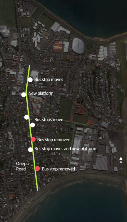
Following discussions with groups in the community and stakeholders, changes to our proposed designs included:

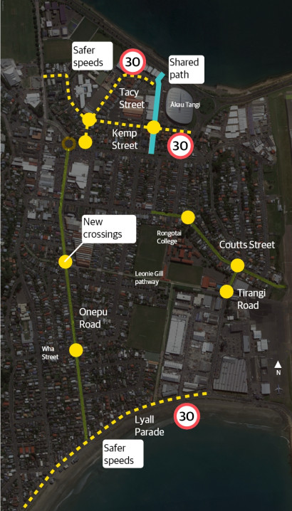
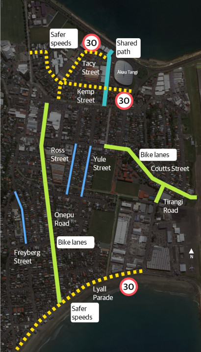
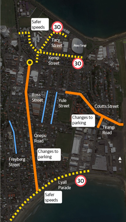
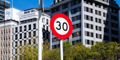
  • Improving safety for people walking and biking by proposals to reduce speeds through:
    • safer speed zones in Lyall Parade, Tacy and Kemp streets
    • installing traffic calming speed humps on Kemp and Tacy streets
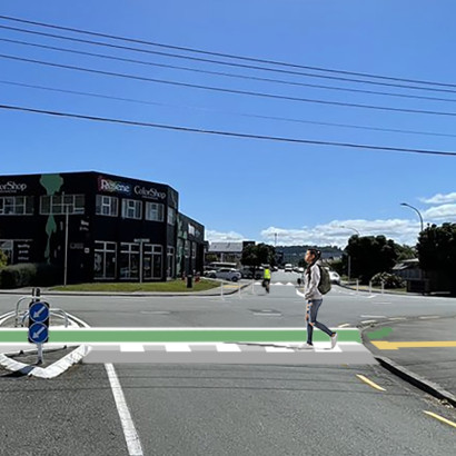
    • raising some existing pedestrian crossings
    • installing new raised crossings.
  • Providing a 30-minute loading zone in Onepu Road adjacent to the Harbour City Funeral Home for hearses
  • Modifying the proposed design for the area around the bus barn entrance following discussions with NZ Bus 
  • Agreeing to explore the possibility of short-term low traffic neighbourhood trials
  • Proposing time restriction and other changes to help with short-stay parking near businesses
  • Improving safety at Pak'n'Save's Onepu Road driveway
  • Suggesting some parking and time restriction changes near businesses experiencing airport-related parking pressures.

As part of our engagement, we’ve worked closely with groups in the community and stakeholders to make changes to the proposed design.

These groups included:

  • Bus services
  • Cycle Wellington
  • Greater Wellington Regional Council
  • Kilbirnie BID (business improvement district)
  • Kilbirnie/Lyall Bay/Rongotai residents group
  • Let’s Get Wellington Moving
  • Living Streets Aotearoa
  • Local businesses
  • Local Police
  • Local schools
  • Rita Angus retirement village
  • Supermarkets
  • Waka Kotahi NZ Transport Agency.
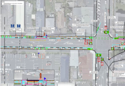
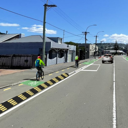
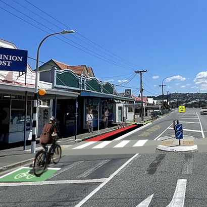
Onepu Road

Onepu Road at the Wha Street intersection. The view is towards the Kilbirnie shopping area (north).

Click and drag to compare

Onepu Road

Onepu Road outside the bus barns. The view is towards the Kilbirnie shopping area (looking north).

Click and drag to compare

Coutts Street

Coutts Street outside Rongotai College. View is towards the airport.

Click and drag to compare

Coutts Street

Coutts Street near the airport underpass. The view is towards the airport.

Click and drag to compare

Tirangi Road

Tirangi Road at the Leonie Gill pathway. View is towards Coutts Street.

Click and drag to compare

Tacy Street

Tacy Street at the Kemp Street intersection. View is towards Evans Bay (north).

Click and drag to compare