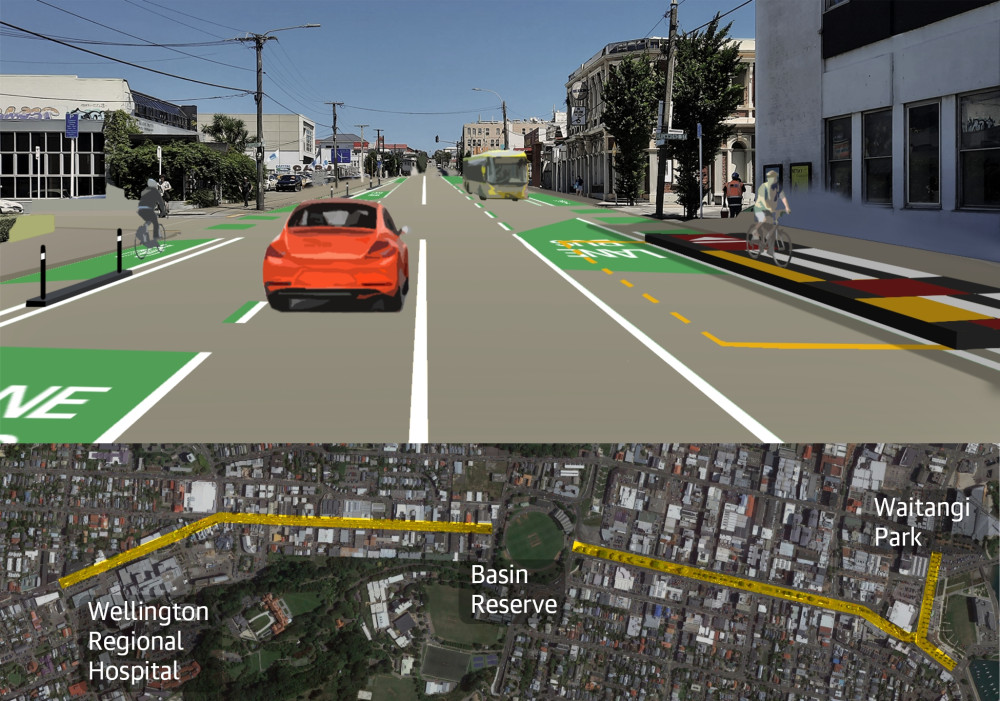
These street changes are now complete. The changes are making it safer and easier to walk, catch the bus, ride a bike, or scooter. You can read more about the Newtown to city street changes on these pages. For questions or comments, you can find the Council's contact details here.

He tāone e hāngai ana ki te anamata
A city fit for the future
We're rebalancing our existing street space to make it safer and easier for more people to walk, ride, scooter, or use public transport. The Newtown to city route is part of the southern connection from Island Bay and the changes we've made here are making it faster and easier for people using public transport and safer for many more people to bike/scoot between Newtown, Wellington Hospital and the waterfront (at Kent Terrace). The route has also been earmarked for possible mass rapid transit in the future.
The changes along these streets have made it safer and easier for people using this busy route and provide more options for how people can get to and from work, school, or tertiary study, drop kids at day care, visit local shops, Wellington Hospital and related health services, or sports and recreation.
How we made the changes
The first section of this route (along Riddiford Street between Mein Street/Hall Street and John Street/Adelaide Road) was initially installed using an experiential approach.
We adapted that approach and took the proposed plans and community feedback through a traffic resolution consultation. The Council approved the plans, and the route was developed using adaptable materials. Following installation, and based on user experience and feedback, some changes were made, including replacing some of the temporary bus stop platforms with more permanent ones.
A monitoring and evaluation report was completed following a full year of the changes being in place, and showed an increase in bus patronage as well as people using bikes and micro-mobility along the route.
Councillors gave approval to consult on a connected citywide bike network that will make streets safer and healthier for everyone, at a meeting of Pūroro Āmua – the Planning and Environment Committee – on 23 September 2021.
At the same meeting, Councillors also voted to get going quickly on two of the critical routes in the bike network - between Newtown and the city and the Botanic Garden ki Paekākā and the city - and develop these using adaptable materials so people can use them, make suggestions, and help to refine the design once they're installed.
Engagement with businesses on the Newtown and Botanic Garden ki Paekākā to city routes started in November 2021.
We worked with technical experts and a stakeholder group to develop the design options and wider feedback was gathered via a public survey and individual conversations with businesses along the route. Data on things like parking use and numbers of people on bikes and buses is being gathered now so we can evaluate the changes in the future.
The bike network plan, Paneke Pōneke, was approved by Councillors on 10 March 2022 following consultation in late 2021.
Following a Council decision in 2021 to accelerate the delivery of a bike network in Wellington, we planned to use a new experiential approach that would help deliver changes faster. We planned to install the route for 12 months using adaptable materials and give the community the opportunity to experience the changes in real time, so that we could make changes in response to their feedback and data we gathered.
Councils have two powers for making and enforcing street changes:
- Traffic resolutions, which are made through bylaw under the Land Transport Act 1998 and are used for more permanent changes, where there is certainty around a proposed design.
- Temporary Traffic Management Plans, which are used for temporary and experimental changes (including things like roadworks), under the Local Government Act 1974.
A small section of the route along Riddiford Street between Mein Street and John Street/Adelaide Road was installed using a Temporary Traffic Management Plan starting in May 2022. However, installation was temporarily stopped in June following a legal challenge.
Since then, the Council has reached an agreement with the group which had sought a judicial review. The agreement included a commitment to consult using the traditional traffic resolution process, which allows us to continue progress along the Newtown to city route.
Central government has acknowledged that the current legislation the Council sought to use is outdated and not fit-for-purpose in the current context, particularly how quickly we need to act in terms of reducing harmful carbon emissions from transport. They are reviewing this legislation as part of their Reshaping Streets programme.
Stay in touch and get involved
The Newtown to City project is now complete. We've taken steps to keep the community involved, including sending updates about opportunities to get involved, and have your say as construction progressed. You can read the newsletter updates below and find out about how the changes are performing here.
If you want to get in touch, email info@wcc.govt.nz If your query is urgent, please get in touch with the City Council call centre on 04 499 4444.