He tāone e hāngai ana ki te anamata
Preparing for the future – more choice for more people
These street changes are now complete. The changes are making it safer and easier to walk, catch the bus, ride a bike, or scooter. You can read more about the Newtown to city street changes, including the monitoring and evaluation report on these pages. For questions or comments, you can find the Council's contact details here.
Te ara
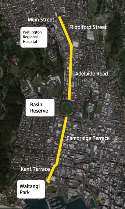
The route – the most important connections
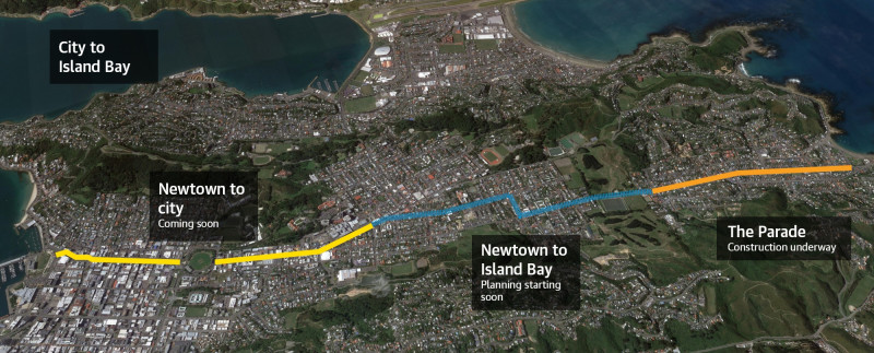
Newtown is only 2km from Wellington central, making it about a 10-minute bike or bus ride into the city.
Newtown through to the city is a key area for growth and intensification under the 2021 Spatial Plan and the proposed District Plan. Street improvements like these will support our growing neighbourhoods so we can cater for more people moving around in the future without our city grinding to a halt.
These improvements also support Wellington Hospital’s Travel Action Plan, which aims to provide more transport choices for the 5000+ staff travelling to the hospital, freeing up parking spaces off-street and in the surrounding area, for people who need it most.
Overall, the changes along these streets will make things safer and easier for people using this busy route and provide more options for how people can get to and from work, school, or tertiary study, drop kids at day care, visit local shops, Wellington Hospital and related health services, or sports and recreation.
From the end of 2021, we began engaging with residents and businesses about planned bus and bike improvements along this route.
Following discussions with groups in the community and stakeholders, we included the following changes in our designs:
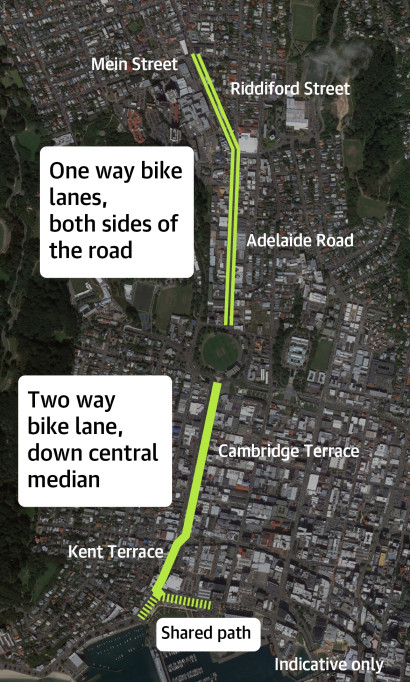
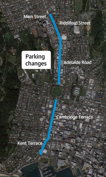
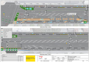
Changes along Riddiford Street, Mein Street and Hall Street:
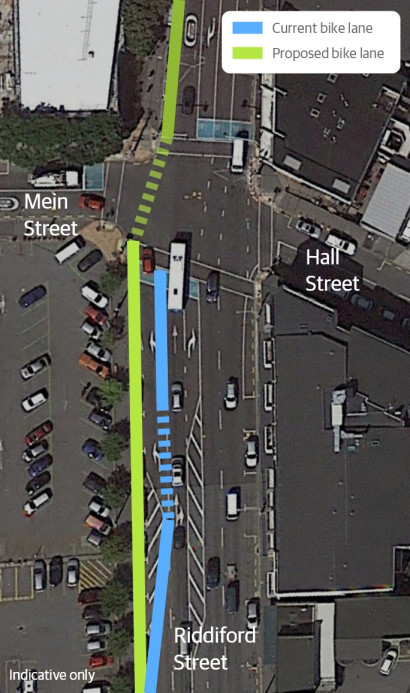
- Improving the bike lane from the hospital leading up to Mein Street by relocating the bike lane to the left-hand side of the road with cycle lane dividers
- Changing the signal phasing and timing so there is a 'protected phase' to avoid conflicts between left-turning vehicles and people on bikes going straight ahead
- Removing an additional six parking spaces on Riddiford Street outside Newtown School to allow the separated bike lane to continue straight at this intersection and merge safely with vehicles
- Relocating loading zone for businesses on corner of Adelaide Road and Riddiford Street to the Hospital car park entrance, with P10 loading during off-peak hours 7pm-7am in the lane
- Removing an additional six parking spaces on Riddiford Street outside Newtown School to allow separated bike lane straight to intersection
- Changing three unrestricted parking spaces to P30 parking spaces on Hall Street to better accommodate people visiting Wellington SCL
- Changing five pick up and drop off parking spaces to P10 parking spaces outside Newtown School on Mein Street
- Changing 17 P60 parking spaces to P120 parking spaces on Mein Street to better suit hospital visitor and appointment times
Changes along Adelaide Road and side streets:
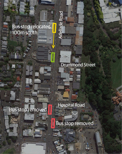
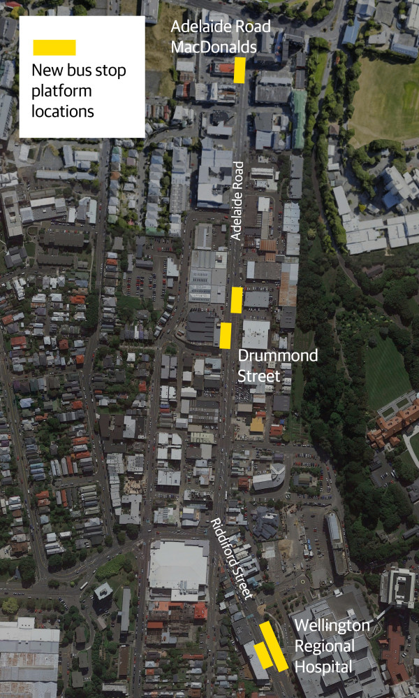
- Changing two coupon parking spaces to P10 parking spaces on Drummond Street for allowing people to be dropped off or picked up from Blind and Low Vision New Zealand and the Blind Foundation, and to accommodate moving cars around for people test driving cars from a nearby business
- Changing two unrestricted parking spaces to P120 parking spaces on Broomhedge Street to facilitate people visiting the dance studio and the brewery
- Keeping eight P60 parking spaces outside accident and emergency centre and starting the separated cycleway after the parking area.
Changes along Kent and Cambridge Terrace
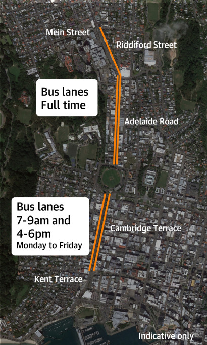
- Changing bus lanes on Kent and Cambridge Terrace to 7am-9am and 4pm-6pm, rather than the originally proposed 7am-7pm, to allow for parking during off-peak bus times.
- Full time loading zone changed to an off-peak loading zone for businesses on Cambridge Terrace, with bus layover at peak times
- Providing additional bus layover on Chaffers Street
- Relocating the taxi stands on Kent and Cambridge Terrace
- Providing additional four metred parking spaces against closed turnarounds on Kent Terrace
As part of our engagement, we’ve worked closely with groups in the community and stakeholders to make changes to the proposed design.
These groups included:
- CCS Disability Action Group
- Cycle Wellington
- Blind and Low Vision New Zealand
- Blind Foundation
- Businesses along the route
- Fire and Emergency New Zealand
- Greater Wellington
- Metlink
- Local schools
- Living Streets Aotearoa
- Taxi companies
- Waka Kotahi
- Wellington Hospital
- Wellington After Hours Accident and Emergency Centre
- Wellington SCL
Evaluating the changes
Once the changes are in, we’ll be monitoring and evaluating community feedback, local economic data, travel times for buses and traffic and use of short-term parking and loading zones.
Longer term, we’ll be tracking things like numbers of people riding bikes and taking the bus, diversity of people on bikes (age and gender), whether more people think the changes are positive, and kilometres of infrastructure installed per year and how long it takes to get things in.
You can read the full set of plans
Find out more and read the full set of plans for the Newtown to city project.
Webinars
In this webinar (recorded on 15 March) you can meet the team and learn about important street changes that are part of the city's goal to be a net zero carbon capital by 2050. We talk you through two projects - Newtown to the city and the Botanic Garden ki Paekākā to the city. The Council's City Design Manager, Vida Christeller, and project lead Renee Corlett share information about the designs and when the changes will happen. The webinar includes a question and answer session, how you can provide feedback on the street changes once they're made and how to keep in contact with the project team.
In this webinar (recorded on 2 June) we talk you through the new bus stop platforms for the Newtown to the city and the Botanic Garden ki Paekākā to the city projects. The webinar includes a question and answer session with panellists from Wellington City Council, Waka Kotahi, Metlink, Zicla and International Design for All.
Riddiford Street
Separated bike lanes on both sides of the road and new bus stop platforms and bus lanes on Riddiford Street (near Wellington Hospital). View towards Newtown.
Image indicative only
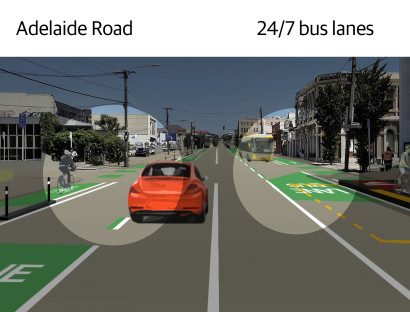
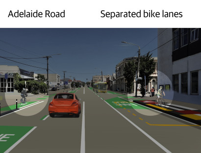
Adelaide Road
Separated bike lanes on both sides of the road and bus lanes on Adelaide Road (near Drummond Street). View towards Newtown.
Image indicative only
Adelaide Road
Separated bike lanes on both sides of the road and bus lanes on Adelaide Road (near McDonald's). View towards the Basin Reserve and city.
Image indicative only
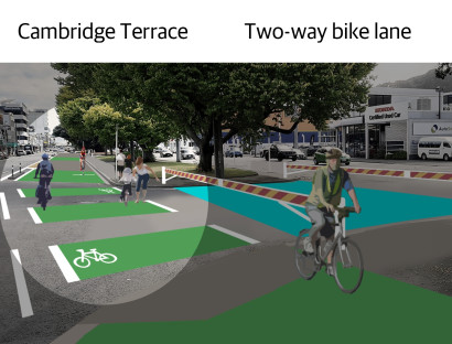
Cambridge Terrace
Two-way separated bike lane on Cambridge Terrace (near the Basin Reserve). View towards the waterfront.
Image indicative only
Supporting documents
Look at the plans, parking management plans, detailed information on the options we considered and more.
Evaluating the changes
We'll be monitoring and evaluating the street changes alongside community feedback.
The options we considered
We developed a list of possible options that could improve this route. We looked at things from a range of perspectives.