The Ngaio Connections project is now complete. If you want to get in touch, email info@wcc.govt.nz If your query is urgent, please get in touch with the City Council call centre on 04 499 4444.
He tāone e hāngai ana ki te anamata
A city fit for the future
We’re rebalancing our existing street space to make it safer and easier for people to walk, ride, and use public transport.
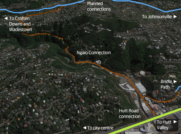
The Ngaio connection is part of the northern route between the central city, Ngaio, Crofton Downs, Khandallah and Johnsonville. In the future, this route will connect through to other projects as part of Wellington's bike network plan.
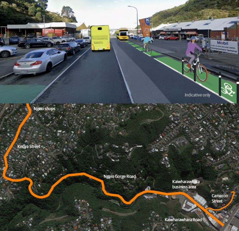
Project at a glance
This 2.9km route makes it easier for more people to bike/scoot from Hutt Road up Kaiwharawhara Road and Ngaio Gorge Road to Crofton Road, and up Cameron Street to the Kaiwharawhara Bridle Path.
Bus and bike improvements along the route include:
- better access to bus stops
- new raised pedestrian crossings
- uphill bike lanes (one-way)
- sharrow road markings going downhill
- safer speeds around Ngaio village and on Cameron Street
- some parking removal and parking changes along the route and on side streets, with a staged approach through the business area on the lower part of Kaiwharawhara Road.
- For full parking details, see parking changes.
This is a primary route as part of the bike network plan, and connects to the existing Hutt Road to city route, and planned future connections to Crofton Downs and Wadestown and Johnsonville via Khandallah.
On 23 September 2021, Councillors gave approval to consult on a connected citywide bike network that will make streets safer and healthier for everyone.
Officers had been asked to look at how the delivery of a bike network could be accelerated, and a new approach was developed to deliver the proposed routes faster.
The transitional programme approach uses adaptable materials so that interim improvements can be installed quickly, so people can start using the routes faster, and then give feedback so the route changes can be refined further for future permanent improvements.
This new approach and the full bike network plan, Paneke Pōneke, went out for consultation in November 2021, and was approved by Councillors on 10 March 2022.
Through Paneke Pōneke and the Bus Priority Action Plan, the transitional programme is rebalancing how we use our existing street space to give people more options for how they get around.
These changes will make it easier for people on bikes, scooters, and buses to move safely around the city.
From June 2022, we began engaging with residents and businesses about planned bus and bike improvements along this route.
Following discussions with groups in the community and stakeholders, we included the following changes in our designs:
- Proposing a staged approach so Kaiwharawhara businesses can adapt to parking changes and consider new ways of using off-street parking spaces, and using clearways during busier times
- Installing an 8am-4pm loading zone at the bottom of Ngaio Gorge
- Removing two car parks at the bottom of Cameron Street to make it safer for everyone
- Changes to parking restrictions along Cameron Street to deter people from other suburbs parking their cars here for long periods
- Changing to an uphill cycle shoulder on Cameron Street to provide a better connection for people riding up to the Kaiwharawhara Bridle Path
- Changing 50km/h to 30 km/h for safer speeds on Cameron Street
- Extending the 30km/h zone from the Ngaio shops through to Crofton Road
- Installing a new raised pedestrian crossing and raising the existing pedestrian crossing on Kenya Street and at the top of Ngaio Gorge Road to make it easier to cross and get to and from bus stops
- Removing car parks on the south side of Kenya Street to make bus trips faster and easier.
As part of our engagement, we’ve worked closely with groups in the community and stakeholders to make changes to the proposed design.
These groups included:
- Bus driver union members
- Cameron Street residents
- Cycle Wellington
- Disability action groups
- CCS Disability Action
- Blind and Low Vision
- D-Sport
- Greater Wellington Regional Council
- Kaiwharawhara businesses
- Let's Get Wellington Moving
- Living Streets Aotearoa
- Metlink
- Ngaio businesses
- Waka Kotahi NZ Transport Agency