He tāone e hāngai ana ki te anamata
A city fit for the future
We’re rebalancing our existing street space to make it safer and easier for people to walk, ride, scooter, or use public transport. The Thorndon connections project is part of connecting Thorndon and Wadestown to the city, making it safer and easier for more people to walk, bike/scoot or use public transport.
The most important connections
Thorndon has a special character, rich in history and heritage. The area is home to our parliamentary precinct, the Wellington Cathedral, and the routes we’re looking at connect to many large employers as well as primary schools, high schools, and Victoria University of Wellington campuses.
Thorndon and the Tinakori Village are just a short five-minute ride from the central city, and an easy walking distance from the train station and bus terminal.
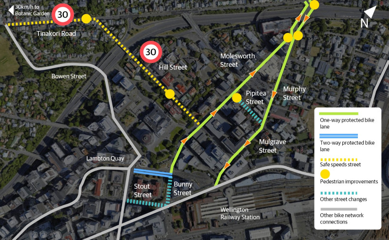
To make it easier for more people to use low carbon transport options to get to, around and through Thorndon, and make it a nicer place to visit and live, we have used adaptable materials to install:
- new separated bike lanes
- new raised pedestrian crossings
- new car share spaces
- new mobility car parks
- bike parking, seats, and planters in Tinakori Village
- an extended 30km/h safer speed zone through Tinakori Village to the Botanic Garden and down Hill Street.
In addition, one bus stop was removed to improve bus travel times, there is better provision for school pick-up and drop-off car parks, and some on-street parking was removed.
Overall, the changes along these streets will make things safer and easier for people getting around this area and provide more options for how people can get to and from work, school or tertiary study, drop kids at day care, visit local shops, churches, and businesses, or live in the area without needing to own a car.
We worked with groups in the community and wider stakeholders to design the improvements along the route. We made changes in response to feedback from the community on the preliminary designs. For full plans, artist impressions, parking impacts and more, see the project details.
We took the proposed plans and community feedback through a traffic resolution consultation. Councillors approved the plans in May 2023.
From November 2022, we began engaging with residents, businesses, organisations and schools about planned improvements for people walking, biking or using buses along these streets. These discussions led to numerous changes in the proposed designs we took to the public for consultation.
Following community feedback through this formal consultation, we took our original proposal along with changes from the community to Koata Hātepe, the Council’s Regulatory Process Committee, for a decision.
The changes we made to the original proposal as a result of community feedback include:
- a one-way bike lane only on the right-hand side of Molesworth Street, rather than the original section of two-way bike lane proposed on Molesworth Street between Lambton Quay and Aitken Street
- this also means that the proposed one-way restriction on Kate Sheppard Place is no longer required and will not go ahead, nor will a proposed section of shared path on the corner of Aitken Street and Molesworth Street
- a separated bike lane on the southern side of Aitken Street will no longer go ahead, preserving the existing angled parking
- bus stop 5112 outside Wellington Cathedral was proposed to be removed but will now be retained
- motorbike parking on the northern side of Aitken Street will be kept
- one of the three proposed diplomatic car parks will be retained as a metered P120 car park.
We will also proceed with a separate traffic resolution to change 11 coupon car parks on Hawkestone Street to P120 car parks, in response to feedback seeking further short-stay parking in the area.
As part of our early engagement, we worked closely with groups in the community and stakeholders to make changes to the original proposed design.
These groups included:
- Apartments
- Archives New Zealand
- Beca
- Bus services
- Cycle Wellington
- Developers working in the area
- Embassies in the area
- Greater Wellington Regional Council
- Let’s Get Wellington Moving
- Living Streets Aotearoa
- Local businesses
- Local schools
- Ministry of Health
- Ministry of Justice
- National Library
- New World
- NZ Police
- Parliament
- Taxi services
- Thorndon Residents' Association
- Victoria University of Wellington
- Waka Kotahi NZ Transport Agency
- Wellington Cathedral
Keep up to date

We've involved the community as the project progressed, including sending updates when there were opportunities to get involved or have your say. You can read the enewsletter updates.
Got questions about this project? Email the team: thorndonconnections@wcc.govt.nz