The options we considered for bike and bus improvements
The aim of Wellington’s bike network plan is to create a citywide network of connected bike routes to improve safety for people on bikes, increase the role of cycling in the transport network, and improve environmental and health outcomes. At the same time, we look to make improvements for people who walk and take the bus.
Our transport planners developed a long list of possible options for how we could improve the busy route from Berhampore to Newtown, looking at things from a range of perspectives, thinking about all the possibilities and what could be achieved in line with best practice and national guidelines.
Plans have been reviewed by various internal and external stakeholders, including Waka Kotahi, Greater Wellington Regional Council, and cycling, walking and accessibility representatives.
As well as safety and comfort for people walking, riding, or taking the bus, we also considered street and vehicle widths, intersections, impacts of lower speeds, loading and servicing for businesses, and the effects on parking availability. Options not progressed to the short list included using other routes, removing building verandahs, and widening streets by digging up kerbs.
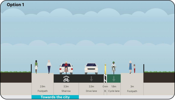
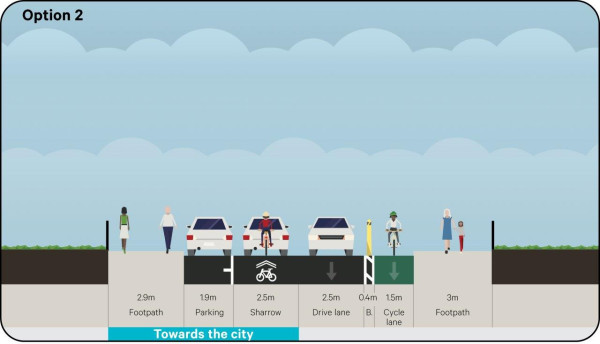
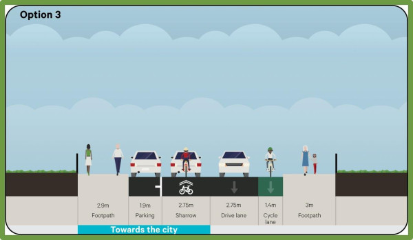
Riddiford Street (Mein Street to Rintoul Street)
There were five options for this section:
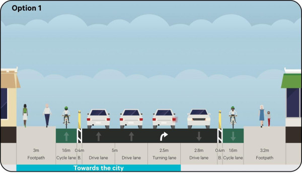
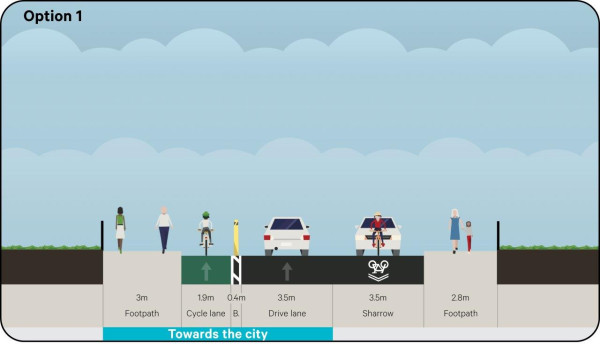
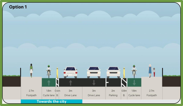
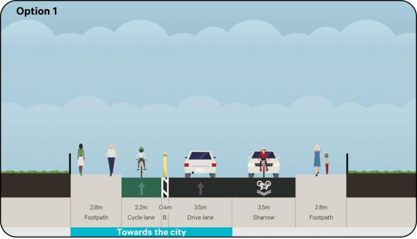
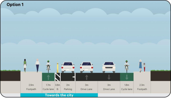
Option 1: separated bike lanes on both sides of the street, removing all parking
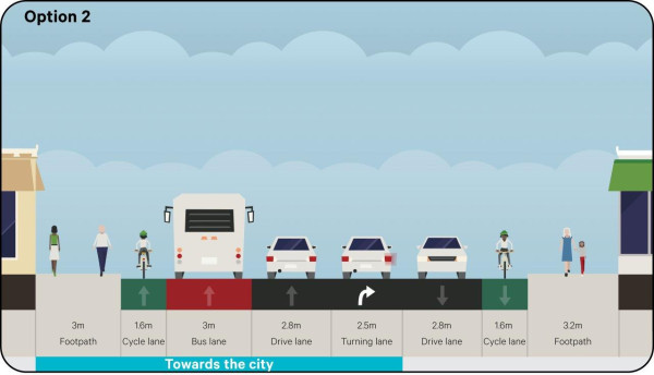
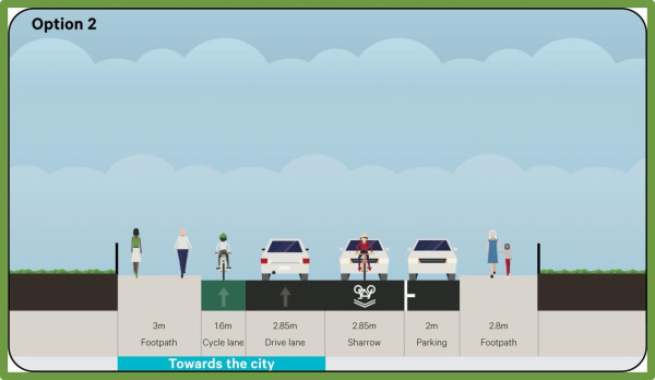
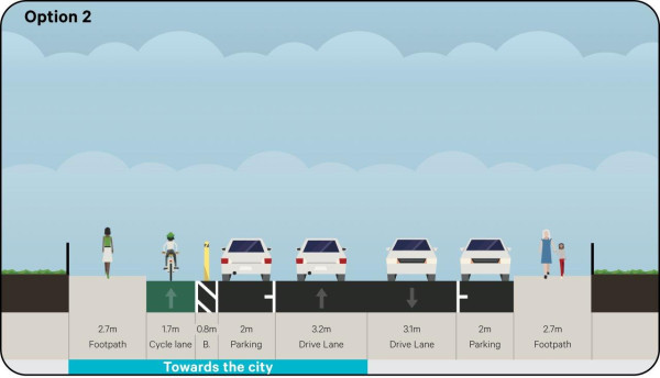
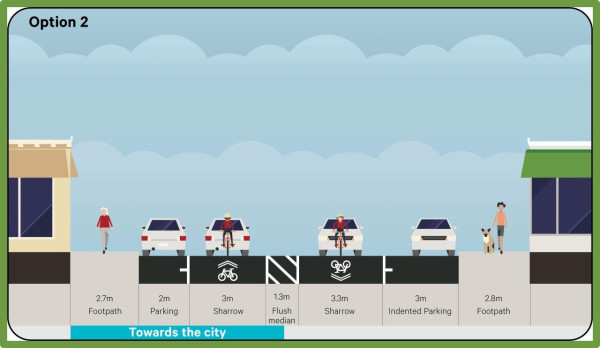
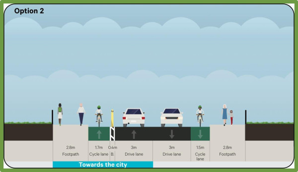
Option 2: on-road bike lanes on both sides, a wider northbound bus lane, removing all parking
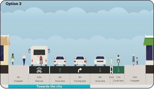
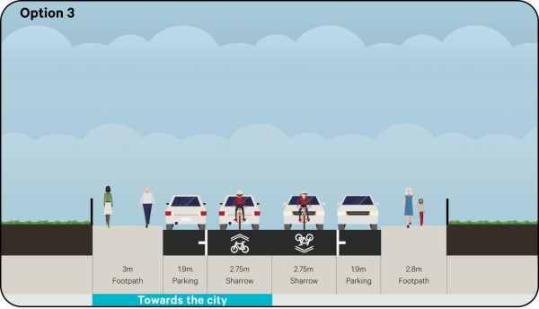
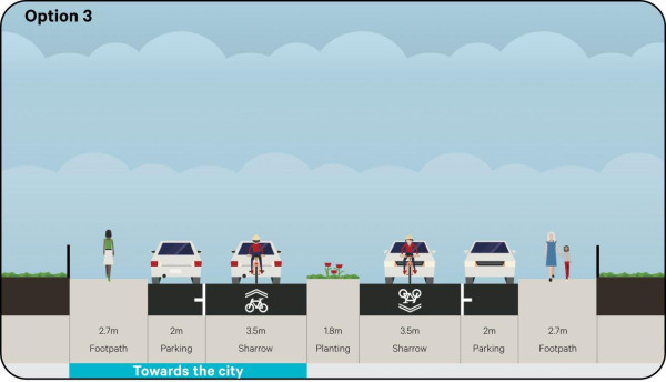
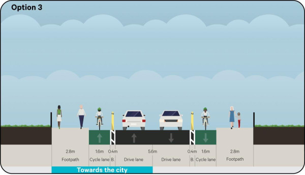
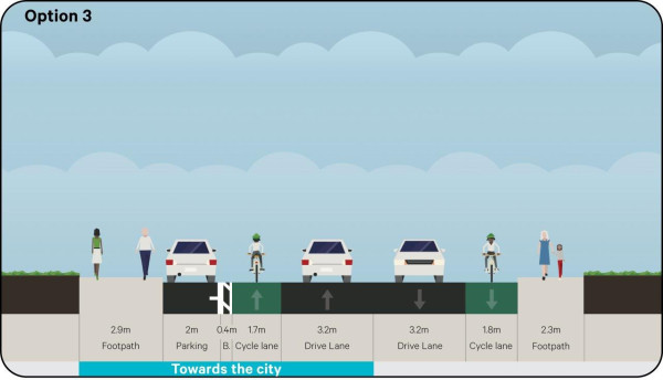
Option 3: separated southbound bike lanes, shared bike/bus lane northbound, wider traffic lanes, removing all parking
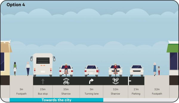
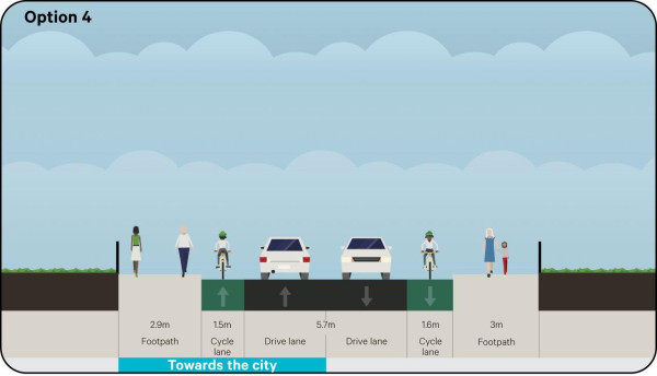
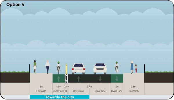
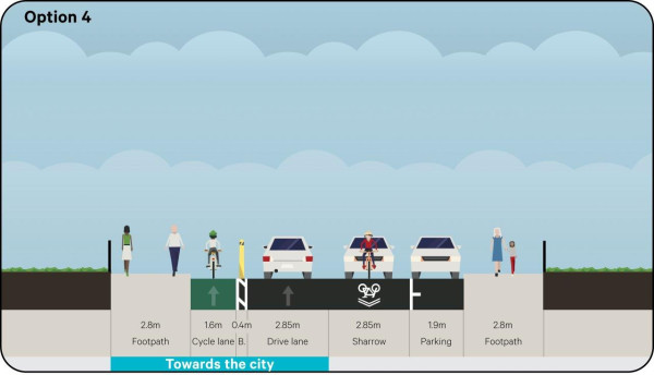
Option 4: shared lanes in both directions, parking on one side, traffic calming, reduced speed environment, wider traffic lanes
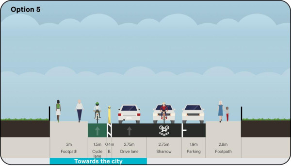
Option 5: separated bike lanes in both directions, wider traffic lanes, remove all parking.
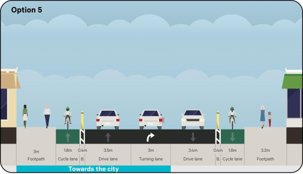
Option 5 scored the highest however we have gone with option 3 (the second-highest scoring option) to minimise the wider network effects on traffic and buses. The shared bus/bike lane approach works as a transition from the shared lane in Rintoul Street and the bus lane and bike lane in the next block of Riddiford Street. Although it would have been ideal to separate the northbound bike lane, the street is not wide enough here to achieve this while maintaining adequate space in the traffic lanes and space for bus users.
Rintoul Street north (Riddiford Street to Wakefield Hospital)
There were four options for this section:
Option 1: separated southbound uphill bike lane, shared northbound downhill traffic lane, no parking, increased traffic lane widths
Option 2: separated southbound uphill bike lane, shared northbound downhill traffic lane, parking on the western side
Option 3: on-road southbound uphill bike lane, shared northbound downhill traffic lane, parking on the western side
Option 4: on-road bike lanes in both directions, no parking, increased traffic lane widths.
Option 1 received the highest score in the MCA however based on the feedback received at this point, we went with option 3 for the 30% design, endeavouring to balance bus, bike, traffic lane widths, and parking requirements in a constrained space. Feedback on the 30% design showed there would be inadequate protection for people on bikes and it would not adequately encourage more people to cycle and keep them safe, particularly school students. Option 2 received the second highest score and retained some parking, so this option was developed to 90% design.
Other considerations included:
- increasing the space on either side of bus stops so buses can pull into the kerb and improving accessibility for everyone
- reducing the number of bus stops where they are too close together and combining bus stops where appropriate to make bus journeys quicker
- creating space for buses travelling in opposite directions to pass each other to help improve bus trips.
Rintoul Street south (Wakefield Hospital to Luxford Street)
There were five options for this section:
Option 1: shared southbound downhill traffic lane, separated northbound uphill bike lane, no parking, increased traffic lane widths
Option 2: shared southbound downhill traffic lane, separated northbound uphill bike lane, parking on the eastern side
Option 3: shared traffic lanes in both directions, traffic calming, 30km/h speed environment, parking on both sides
Option 4: on-road southbound downhill bike lane, separated northbound uphill bike lane, no parking
Option 5: shared southbound downhill traffic lane, separated northbound uphill bike lane, parking on the eastern side.
Option 1 received the highest score however based on the feedback received at this point we went with option 2 for the 30% design, endeavouring to balance bus, bike, traffic lane widths, and parking requirements in a constrained space. Feedback on the 30% design showed there would be inadequate protection for people on bikes and it would not adequately encourage more people to cycle and keep them safe, particularly school students. Option 5 received the third highest score in the MCA and retained some parking, so this option was developed to 90% design.
Other considerations included:
- improving pedestrian safety for Arvida Village residents, school students and hospital visitors
- improving visibility along the route
- improving bus priority and bus stop access
- improving bus tracking around the Luxford Street/Rintoul Street corner
- considering how to get people on bikes around the Luxford Street/Rintoul Street corner in a fully protected bike lane, particularly school students.
- making the Rintoul Street/Luxford Street corner safer for everyone given the feedback we have received from people using this area and data that shows this corner as one of the highest crash and near miss locations on the whole route.
Luxford Street
There were three options:
Option 1: separated two-way bike lane, parking on one side of the street
Option 2: shared traffic lane towards Adelaide Road, separated bike lane towards the city, parking on both sides
Option 3: shared traffic lanes in both directions, traffic calming and planting, 30km/h speed environment, parking on both sides.
Option 1 received the highest score and feedback confirmed this as the preferred option to progress to 30% design. Luxford Street is wide enough to accommodate separated bike lanes and retain some parking.
Other considerations included:
- further traffic calming consistent with a 30km/h zone
- investigating the right-turn Stop sign layout at Rintoul Street and safer solutions.
Adelaide Road (Luxford Street to Britomart Street)
There were two options for this section at the Berhampore shops:
Option 1: shared southbound traffic lane, separated northbound bike lane, indented parking on the eastern side, reinforce 30km/h speed environment

Option 2: shared traffic lanes in both directions, traffic calming, 30km/h speed environment, raised pedestrian crossings, parking on both sides (a clearway on the western side, indented parking on the eastern side).
Option 2 scored the highest and is the one we selected.
Other considerations included:
- making this area safer for pedestrians and people on bikes, especially riders turning right at Luxford Street
- lowering vehicle speeds through the area and reinforcing the 30km/h speed limit. People who live in the area and business owners have expressed concerns about safety and a desire for traffic calming (traffic monitoring showed that over half of the vehicles through here are travelling faster than the 30km/h limit)
- improving bus travel for passengers by combining bus stops
- looking at the operational needs of businesses and positioning of loading zones
- parking for people shopping in the area, including mobility parking
- integrating these street changes for bikes and buses with the Berhampore town centre upgrade.
Adelaide Road (Britomart Street to north end of Wakefield Park)
There were four options for this section:
Option 1: shared southbound traffic lane, separated northbound bike lane, remove all parking, increased traffic lane widths
Option 2: southbound bike lane, separated northbound bike lane, remove all parking, increased traffic lane widths
Option 3: separated bike lanes in both directions, remove all parking
Option 4: shared southbound downhill traffic lane, separated northbound uphill bike lane, parking on the eastern side.
Options 2 and 3 rated the highest however we selected a combination depending on the gradient of the road. These options provide a consistent protected cycle route for people heading towards the city, with continuity from the existing bike lanes on The Parade through to Berhampore, for this busy route that already has high cycle usage and high potential for more.
Other considerations included:
- increasing lane widths for buses and improving bus efficiency and access to bus stops
- making use of any extra road reserve
- alternative parking available for residents in surrounding streets
- improving safety for pedestrians particularly around the bus stops on Duppa Street, for people living in community housing, and students at Berhampore Primary School.
Adelaide Road and The Parade (Wakefield Park to Dee Street)
There were three options for this section:
Option 1: southbound bike lane, separated northbound bike lane, parking on the western side
Option 2: shared southbound downhill traffic lane, separated northbound uphill bike lane, parking on both sides, reduced traffic lane widths

Option 3: bike lanes in both directions, parking on the western side.
Option 1 received the highest score however we decided to proceed with option 2 to 30% design because of the importance of the regional sports centre at Wakefield Park and consistency with designs on similar corridors in Wellington.
Other considerations included:
- reducing pinch points created by extended kerbs
- improving safety by slowing downhill bikes as the road flattens out towards Dee Street
- improving access to bus stops and the efficiency of bus trips
- consistent design along the route where possible
- retaining most parking in the Wakefield Park area (parking would be removed only where required around driveways for visibility).
For full details you can read the options considered and multicriteria analysis.