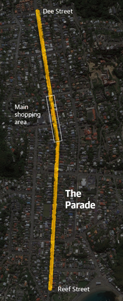
The changes we consulted on – to make The Parade safer for everyone

The improvements we're making will make The Parade safer and more accessible for everyone. The changes north and south of the main shopping area are now complete and construction in the main shopping area is underway.

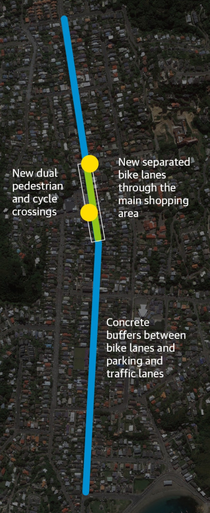
The changes will provide a continuous protected biking route between Dee and Reef streets, and encourage more people to get around in climate-friendly ways. This route will connect with the planned changes through Berhampore and Newtown, and to the central city. Greater visibility at intersections and driveways, slightly wider traffic lanes and a consistent street layout will make it easier for drivers to negotiate The Parade, and improve the look and feel of the street.

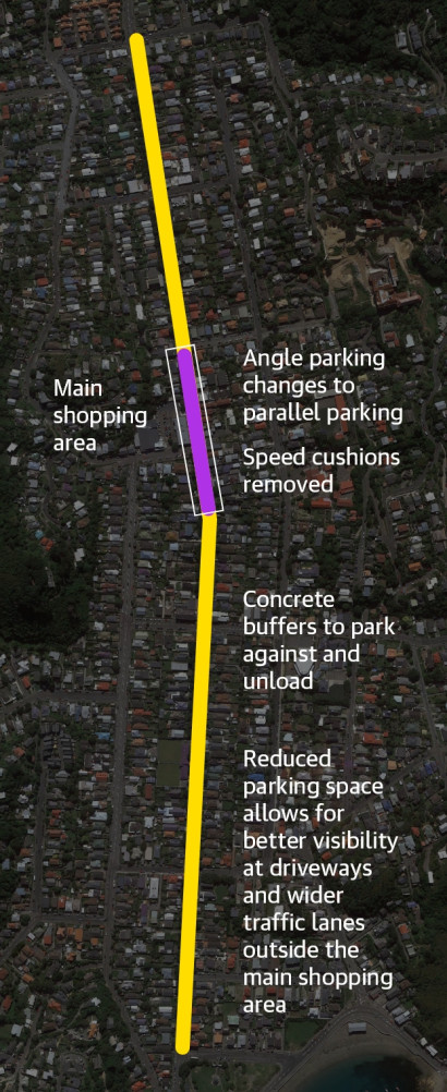
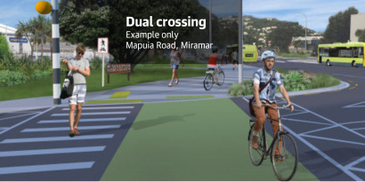
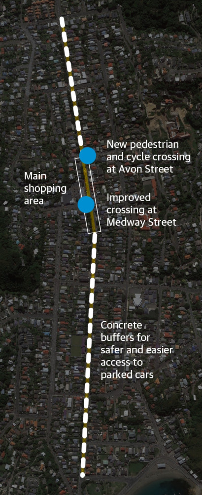
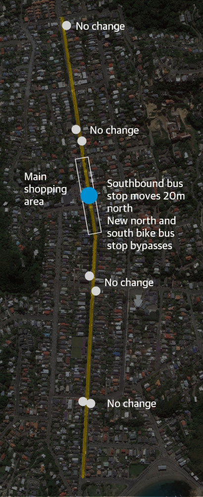
A new layout through the main shopping area (the 30km/h zone) will add separated bike paths, provide more footpath space in some places and reduce vehicle speeds.

The safety changes overall will reduce the amount of street space available for parking, particularly south of the 30km/h zone where the road is narrower. Mobility parking is mostly unaffected apart from slightly relocating one space.

The agreed changes are for all the different ways people use the street.

The improvements will bring the bike lanes and related street layout in line with New Zealand and international design standards:

  • Waka Kotahi NZ Transport Agency's cycling network guidance
  • Austroads guidance
  • Wellington City Council's design guidance
  • Waka Kotahi's manual of traffic signs and markings (MOTSAM), pedestrian planning and design guide, and guidelines for public transport infrastructure and facilities.

Changes at a glance

The route 22x

The route

We’re making changes that will make The Parade safer and more accessible for everyone. 

Impacts

North and south of the 30km/h zone - between Dee and Avon, and Mersey and Reef - we will be using the existing street space to:

  • put in raised concrete buffers between the bike lanes and parking to provide greater protection for people on bikes/scooters, and give something for people to park against and get in and out of cars
  • put in raised buffers between the bike lanes and traffic lanes in places where they are adjacent (no parking spaces in between)
  • improve visibility by moving car parking further back from all driveways and intersections
  • slightly widen traffic lanes 
  • provide clear and consistent road markings, particularly at side-street intersections.

In the 30km/h zone - between Avon and Mersey - we plan to change the street layout to:

  • complete the cycle/scooter route through Island Bay by installing new separated bike/scooter lanes on both sides of the street at footpath level, between the footpath and parking 
  • replace all the angle parking with parallel parks
  • extend some kerbs to encourage safer speeds and create space for new low planting
  • possibly remove some trees but we won’t know how much space is needed until we do the detailed design.

1 / 5

Driving 22x v2 Buffer image2x

Changes for people driving

With slightly wider traffic lanes along most of The Parade, separation between bikes and cars through the 30km/h zone, better visibility at driveways and intersections, and raised buffers between the bike lanes and car parking, The Parade will be safer and easier for general traffic and buses.

Impacts
  • Clear and consistent street layout and markings, particularly at side-street intersections
  • New 0.9m-wide raised concrete buffers will make it easier for people to park and load/unload their cars (similar to the ones on Rongotai Road in Kilbirnie)
  • Raised concrete buffers between the bike lanes and traffic lanes in places where they are adjacent (no parking spaces in between)
  • Low rubber dividers that can easily be driven over to show where driveways are and encourage safer speeds (similar to Rongotai Road)
  • Slightly wider traffic lanes between Dee and Avon, and Mersey and Reef, up from 3m to 3.2m wide
  • Car parking set further back from all driveways (3m) and intersections (30m) to improve visibility for everyone 
  • Reduced amount of street space available for parking, particularly south of the 30km/h zone where the road is narrower, so the traffic lanes can be widened and visibility improved around driveways and intersections
  • Mobility parking mostly unaffected apart from slightly relocating the space near 134 The Parade to just around the corner onto Medway, before the taxi stand
In the 30km/h zone – between Avon and Mersey
  • New street layout to make this area safer and easier for everyone
  • New separated bike/scooter lanes at footpath level on both sides of the street, between the footpath and parking, to provide a continuous protected route along The Parade 
  • All angle parking changed to parallel parking
  • Slightly narrower traffic lanes, 3.2m wide instead of 3.6-3.9m but vehicles won't have to share the lane with bikes
  • New dual pedestrian and cycle crossings at footpath level over Avon and Medway
  • Some kerbs extended out to encourage safer speeds
  • Existing speed cushions removed
  • Raised crossings retained

2 / 5

Bike scooter 22x v2 Buffer image2x Dual crossing2x

Changes for people riding bikes/scooters

Improvements to the existing bike lanes and adding new separated lanes through the 30km/h zone will create a connected route through Island Bay and complete this part of the city to south coast connection. Other changes to the street layout will improve visibility and provide a greater level of protection.

Impacts
  • In the 30km/h zone (between Avon and Mersey) - new 1.2m–1.5m-wide separated bike lanes at footpath level between the footpath and parking so people on bikes don’t have to share the lane with vehicles 
  • All angle parking between Avon and Mersey changed to parallel parking to make space for the protected bike lanes
  • New bus stop bypasses at the two bus stops in the main shopping area (the same as other bus stops on The Parade, where the bike lane goes behind the bus shelter)
  • Between Dee and Avon, and Mersey and Reef - new 0.9m-wide raised concrete buffers installed between the bike lanes and parking similar to the ones on Rongotai Road in Kilbirnie 
  • Raised buffers between the bike lanes and traffic lanes in places where they are adjacent (no parking spaces in between)
  • Low rubber dividers that can easily be driven over to show where driveways are and encourage safer speeds (similar to Rongotai Road)
  • Car parking set further back from all driveways (3m) and intersections (30m) to improve visibility for everyone
  • Clear and consistent road markings, particularly across side streets
  • Two new dual pedestrian and cycle crossings at footpath level over Avon and Medway to improve safety 
  • Slightly narrower bike lanes between Dee and Tamar (1.5m wide instead of 2m) to make space for the buffers and to widen the traffic lanes
  • Slightly wider bike lanes between Mersey and Reef (1.9m–2.1m wide)

3 / 5

Walking 22x Dual crossing2x

Changes for people walking

Pedestrian safety will be improved on The Parade. Two new side-street crossings and concrete buffers between the bike lanes and car parking will make things safer and easier for people on foot. We’re also improving visibility by moving car parking where it’s too close to driveways and intersections.

Impacts
  • New dual pedestrian and cycle crossing at footpath level over Avon Street, and upgrading the existing raised crossing over Medway to be a dual crossing, to improve visibility and safety at these intersections
  • New 0.9m-wide raised concrete buffers between the bike lanes and car parking to make it safer and easier for people getting in and out of their cars, and crossing to/from the footpath (similar to the ones on Rongotai Road in Kilbirnie)
  • Car parking set further back from all driveways (3m) and intersections (30m) to improve visibility for everyone
  • In the 30km/h zone - between Avon and Mersey - new 1.2m–1.5m-wide separated bike lanes at footpath level between the footpath and parking so people on bikes don’t have to share the lane with vehicles
  • Slightly narrower and variable footpath width on the western side through the main shopping area between Avon and Mersey (4.5–5.7m wide instead of 5.9m) to make space for the new separated bike lanes
  • Raised crossings in the 30km/h zone retained
  • Some kerbs extended in the 30km/h zone to encourage safer speeds and make space for low planting

4 / 5

The bus 22x

Changes for people using the bus

Most bus stops along The Parade will stay as they are now.

Impacts
  • Southbound bus stop opposite Medway Street moved about 20m further north (the northbound stop is unchanged)
  • New layout at the two bus stops in the 30km/h zone, with the bike lanes going behind the bus shelters (the same as the other bus stops on The Parade)
  • All other bus stop bypasses remain as they are

5 / 5

What's next?

Councillors considered the feedback and other factors, including identified safety concerns, and made decisions on the proposals at a meeting of Pūroro Āmua, the Planning and Environment Committee, on Thursday 10 March 2022. In mid-2022, concrete buffers and other safety improvements were put in place north and south of the main shopping centre.

Construction for the safety and other improvements in the 30km/h zone (between Avon and Mersey) will happen in 2024. 

View the plans we consulted on

Main shopping area

Proposed changes in the main shopping area (in the 30km/h zone) .

Click and drag to compare

Section 7

Click and drag to compare

Section 8

Click and drag to compare

Section 9

Click and drag to compare