Consultation closed
Thank you to everyone who provided feedback on the proposed changes for Wadestown. All community feedback will be presented to Koata Hātepe, the Council’s Regulatory Processes Committee, later in the year.
He tāone e hāngai ana ki te anamata
A city fit for the future
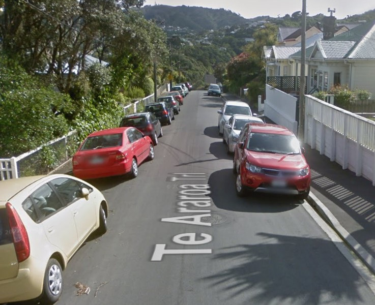
Wadestown is a city fringe suburb on steep hills. It’s mainly residential with shops and businesses in the village area and on Sefton Street/Lennel Road.
Streets are often narrow and winding with limited visibility, and more parked cars than safe space available. Many commuters also park in the Wadestown area.
In response to community feedback, and to prevent streets in Wadestown grinding to a halt, we're proposing important changes to parking that will prioritise residents and short-stay visitors and improve safety and access.
We are also making street changes to provide more transport options, complete the Wadestown bike connection, and improve bus trips.
What this project involves
We've heard from the Wadestown community that parking is under pressure, with commuters parking in residential streets for long periods and some streets clogged with parked cars so it's hard to navigate a safe way through. We're responding to people's feedback with several proposals. The areas we’re focused on are:
- introducing a parking scheme for part of Wadestown that would make it easier for residents with no off-street parking, to park closer to home, while still allowing for tradespeople, visitors and shoppers
- improving safety and access by limiting where you can park on some streets, particularly so buses, emergency vehicles and rubbish/recycling trucks can get through
- installing an uphill bike lane on Blackbridge Road and Wadestown Road from Churchill Drive to Wadestown shops and improving bus journeys on this section of Wadestown Road.
View the details
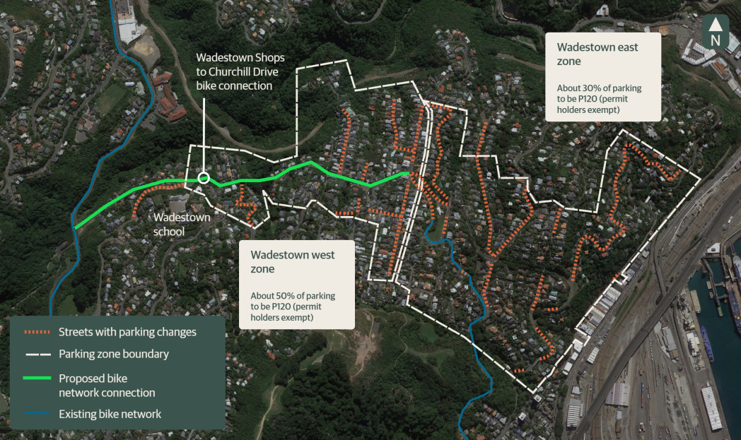
Parking changes in Wadestown
View the interactive Wadestown map. You can quickly and easily look up an address, zoom in/out and view the streets before and after the proposed changes.
Bike and bus improvements
We’re proposing street changes for a better bike and bus connection from Churchill Drive to Wadestown shops.
Part one of this project connects from Tinakori Road via Park Street and Grant Road, up Wadestown Road to the Pitt Street intersection.
Our initial investigations showed there were limited options for this section, so we had early discussions with residents in the area before a traffic resolution consultation on proposed changes from 14 August to 28 August 2023.
The proposed plan was to install an uphill bike lane along Park Street, a short section of Grant Road, then up Wadestown Road to the intersection of Wadestown Road and Roscoe Terrace. This proposed change included relocating and removing some parking spaces.
These changes would make it safer and easier for everyone travelling up Wadestown Road, as it would mean people driving wouldn't get stuck behind people biking uphill, and drivers would no longer need to cross the centreline to pass parked cars.
These street changes were approved by Koata Hātepe, Council’s Regulatory Processes Committee, on 5 October 2023 with a number of amendments following community engagement:
- keep the existing lane layout at the Park Street/Tinakori Road intersection and add a green slip lane for people on bikes to get to the advanced stop box at the traffic lights
- install a mobility park outside 97 Grant Road and remove the separated bike lane between 19 Park Street and 107 Grant Road until the mobility park is no longer required
- keep one residents parking space outside 107-109 Grant Road
- change 11.6m of coupon parking to residents parking opposite 111-113 Grant Road
- change one coupon park to residents parking opposite 113 Grant Road (so there will be three residents parking spaces in that area)
- move the proposed 10m of No Stopping lines opposite 75 Wadestown Road further north to be opposite 77 Wadestown Road for better sightlines.
At the same meeting, Koata Hātepe approved street changes on Churchill Drive which will help provide future connections through to Crofton Downs and Wilton, including:
- installing speed humps on the approaches to two pedestrian crossings to slow vehicle speeds
- painting broken yellow lines in the downhill directions on Churchill Drive
- installing uphill bike lanes along Churchill Drive – towards Crofton Downs between Blackbridge Road and Chartwell Drive, and towards Wilton from Wilton Bush Road to Wilton Road.
The changes approved included the following amendments following community engagement:
- reduce the No Stopping lines by 50m to leave space for up to eight cars to be parked on the street near 11 -21 Churchill Drive
- install a 15m section of asphalt footpath so people can get from the track to Izard Park to a safer pedestrian crossing point
- add 32m of No Stopping lines on the eastern side of Churchill Drive, north of Blackbridge Road, to improve safety.
You can find full information about these decisions, including the agenda, minutes, and video of the meeting, on the Council website.
In part two, from Wadestown shops down Wadestown Road and Blackbridge Road, there has been more to explore with the residents and businesses to understand what will best suit this area.
Our initial investigations suggested that we can increase safety in the shopping area by reducing vehicle speeds. However, wider parking changes in Wadestown are part of talking with the community.
People in Wadestown have told the Council that parking in some parts of Wadestown is under pressure, so we are proposing a new parking scheme in line with our Parking Policy 2020 and new no stopping lines on some streets to improve safety and access.
Any bike lane changes will undergo a full road safety audit.
In the early stages of Wadestown connections part 1, through our engagement with the community we heard their desire for the Council to present its work on transport corridors as one cohesive project, rather than addressing the needs of the community through isolated projects.
During the development of designs for Wadestown connections, we hosted two walking tours along the route to hear the community perspective on how the streets were currently being used. Through this, we progressed our understanding of the key themes we were hearing through community feedback. Wadestown residents wanted their streets to be safer and more accessible for all vehicles, including emergency vehicles, and felt a plan to manage parking was needed to prioritise parking spaces for residents.
At the end of 2023 we went out with a baseline survey to the Wadestown community and heard from 292 people on how they were experiencing the streets at present.
In early 2024, we came back to the community with a high-level proposal that incorporated what we had heard from previous conversations with residents, and the baseline survey responses. We hosted two drop-in sessions at Wadestown Library to gain feedback on the broader proposal to manage parking, improve safety and accessibility on streets, and provide transport options with the inclusion of a bike lane. We used community feedback and met with key stakeholders including Fire and Emergency New Zealand, Waka Kotahi and Greater Wellington Regional Council to further refine our designs.
Wellington is expected to grow over the next 30 years, which will dramatically affect the way our city looks, feels, and operates. If we continue at our current rate of car use, our transport network will grind to a halt.
Our goal is to be a city where people of all ages and abilities can move easily and freely in low-carbon ways. These essential street changes will make it easier for more of us to be less reliant on our cars.
We’re changing our streets to make it safer and easier for people to walk, ride, scoot, or use public transport. The changes we’re developing will take time to get used to, but we need to adapt to make sure we can still get around.
In line with Council strategies, policies, and plans, we have developed Paneke Pōneke, a citywide bike network plan. Changes as part of Paneke Pōneke will happen alongside improvements for people walking, scooting, and taking the bus.