The content on this page was accurate at the time of the traffic resolution consultation, and some changes were made to the project as a result of community feedback. We've kept this page to make sure we are being transparent about our process and to show how the project has developed. The main project page is the most up to date place, and more information about the Council's decision can be found in the meeting minutes. 

He tāone e hāngai ana ki te anamata
Preparing for the future – more options for more people

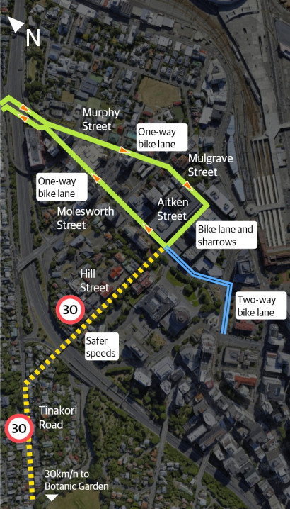
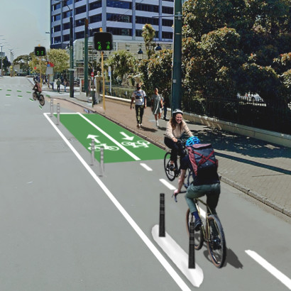
The changes along these streets will making things safer and easier to use low-carbon transport options – whether you’re walking, riding a bike or scooter, or catching the bus.

Ngā panonitanga I Changes at a glance

The connections2x

The connections

The changes along these streets will make things safer and easier for everyone.

Impacts:

  • New separated bike lanes on right side of road
  • New raised pedestrian crossings
  • New car share spaces
  • New mobility car parks
  • Bike parking, seats, and planters in Tinakori Village
  • Extending safer speed zones through Tinakori Village to Botanic Garden entrance and on Hill Street
  • Removing two bus stops to improve bus travel times
  • Reduced on-street parking and changes to parking restrictions in the area

See the impacts in more detail for each section:

1 / 5

Walk2x

Changes for people walking

Pedestrian safety and accessibility will be improved with safer speeds and traffic calming.

Impacts: 

  • Raise the existing pedestrian crossings on Tinakori Road, Hill Street and the motorway overbridge at the top of Molesworth and Murphy streets 
  • New raised pedestrian platform on Pipitea Street
  • New shared zones on the corners of Molesworth Street/Aitken Street and Bunny Street/Thorndon Quay where people on bikes can bypass the intersections and reduce conflict with vehicles 
  • Providing dedicated space for people on bikes as well as new bike parking in the shopping village on the roads should create clearer footpath areas for pedestrians
  • Extended 30km/h safer speed zones through Tinakori Road up to the Botanic Garden ki Paekākā entrance and down to Hill Street.

2 / 5

Bike2x Artboard 2 Copy2x

Changes for people on bikes

These changes will create a safer and more connected route for people riding bikes.

  • New uphill separated bike lane on the right side of Molesworth Street to avoid the motorway on-ramp   
  • New downhill separated bike lane on the right side of Murphy and Mulgrave streets to avoid the motorway off-ramp
  • A section of separated two-way bike lane connecting the Golden Mile (Lambton Quay at Whitmore Street) to Bunny Street then up Molesworth Street to Aitken Street
  • New separated bike lane on Aitken Street for those travelling from Mulgrave to Molesworth streets
  • More bike parking in Tinakori Village
  • Sharrows on Hill Street and Pipitea Street
  • Safer speeds with extended 30km/h zone on Tinakori Road through to Botanic Garden entrance and on Hill Street
  • Raised pedestrian crossings in the area and speed humps on Hill Street

3 / 5

Bus2x 1

Changes for people using the bus

Bus journeys will be quicker and easier.

Impacts:

  • Removing two bus stops along Molesworth Street to improve bus travel times:
    • bus stop 5112 Molesworth Street at the Cathedral
    • bus stop 5114 Molesworth Street at SH1 motorway
  • New raised bus stop platform at bus stop 4114 Murphy Street at SH1 motorway
  • Relocate school bus stop 5500 on Lambton Quay to Stout Street, and change in bus stop from the north to the south side of Bunny Street with a reduction in hours.

4 / 5

Driving2x 1 Artboard 2 Copy 22x

Changes for people driving

Impacts: 

  • Reduced vehicle lanes on Molesworth Street mostly during construction of new apartments
  • Extended 30km/h safer speed zone on Tinakori Road up to the Botanic Garden ki Paekākā entrance, and down Hill Street
  • Raise the existing pedestrian crossings on Tinakori Road, Hill Street, and the motorway overbridge at the top of Molesworth and Murphy streets 
  • New raised pedestrian platform on Pipitea Street
  • Removing the right turn for people driving from Murphy Street into Pipitea Street
  • Changing Kate Sheppard Place to be one-way only – entering from Molesworth Street and exiting onto Mulgrave Street
  • New mobility car parks on Molesworth, Aitken, and Pipitea streets and Tinakori Road
  • Reduced on-street parking and changes to parking restrictions in the area
  • See parking changes for more detail


5 / 5

Expand All

From November 2022, we began engaging with residents, businesses, organisations and schools about planned improvements for people walking, biking or using buses along these streets.

Following discussions with groups in the community and stakeholders, we included the following changes in our proposed designs:

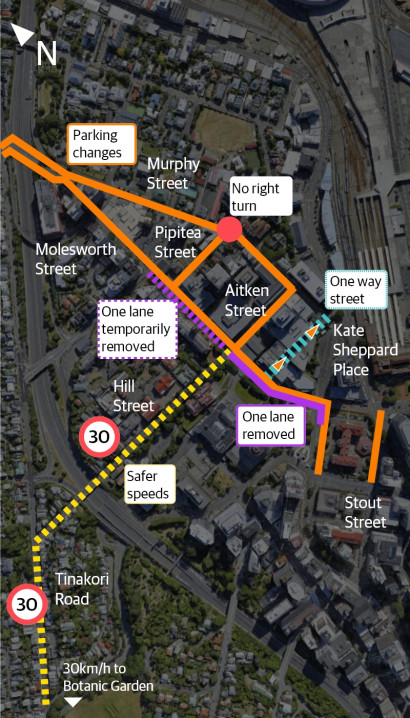
  • Improving safety for people walking and biking by reducing speeds by:
    • Extending the existing safer speed zone in Tinakori Village and introducing a safer speed zone on Hill Street
    • Installing traffic calming speed humps on Hill Street
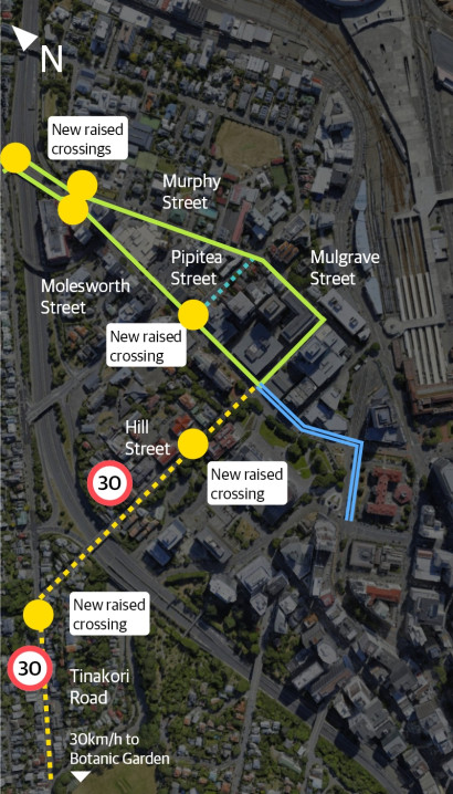
    • Raising the existing pedestrian crossings
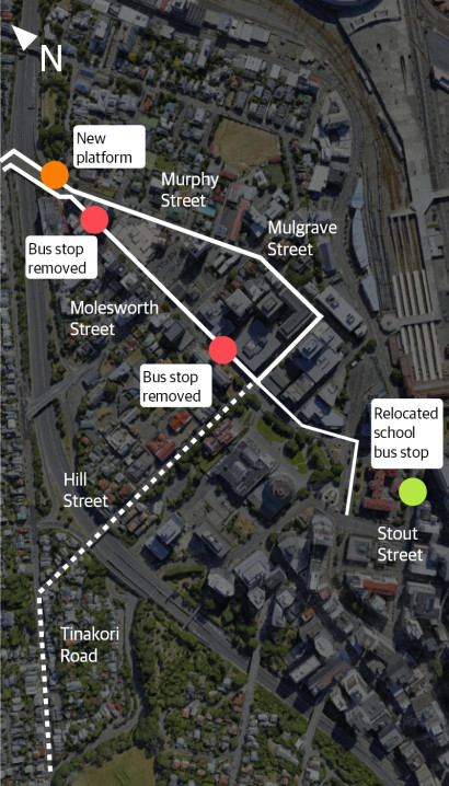
    • Installing new raised pedestrian platform
  • Installing a parklet in Tinakori Village with planters, bike parking, and seats
  • Installing more mobility car parks
  • Installing diplomatic car parks
  • Improving school pick-up and drop-off car park availability
  • Introducing new car share parks.

As part of our engagement, we’ve worked with groups in the community and stakeholders to refine the proposed designs and hear their views.

These groups included:

  • Apartments
  • Archives New Zealand
  • Beca
  • Bus services
  • Cycle Wellington
  • Developers working in the area
  • Embassies in the area
  • Greater Wellington Regional Council
  • Let’s Get Wellington Moving
  • Living Streets Aotearoa
  • Local businesses
  • Local schools
  • Ministry of Health
  • Ministry of Justice
  • National Library
  • New World
  • NZ Police
  • Parliament
  • Taxi services
  • Thorndon Residents' Association
  • Victoria University of Wellington
  • Waka Kotahi NZ Transport Agency
  • Wellington Cathedral

Read a full set of plans and the traffic resolution

You can see the full plans and traffic resolution, as well as other supporting documents.

Lambton Quay

Lambton Quay at Whitmore Street. View looking north towards Molesworth Street

Click and drag to compare

Molesworth Street

Lower Molesworth Street at Kate Sheppard Place. View is looking north towards Wadestown.

Click and drag to compare

Aitken Street

Aitken Street. View towards Molesworth Street.

Click and drag to compare

Molesworth Street

Molesworth Street outside New World. View looking north towards Wadestown.
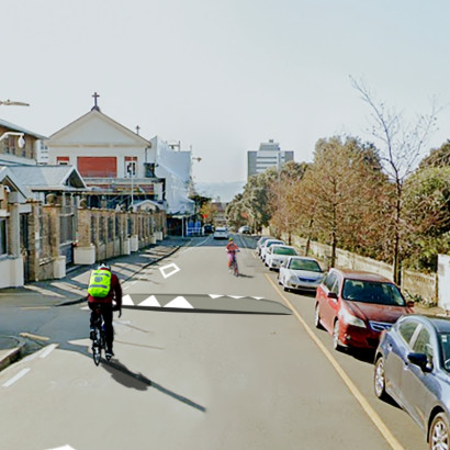
Click and drag to compare

Hill Street

Hill Street. View towards Molesworth Street.

Click and drag to compare

Murphy Street

Murphy Street outside New World. View looking south towards the central city.

Click and drag to compare