He tāone e hāngai ana ki te anamata
A city fit for the future
Karori is already Wellington’s largest suburb, and its population is growing.
To help support this growth, and to provide safer, easier, and climate-friendly ways for people to get around, we’re making changes on some streets for people using footpaths, bikes, scooters and buses.
Karori connections is the Karori section of Wellington's bike network. As well as improvements for people on bikes, we’re also making changes to make journeys for pedestrians and bus passengers safer and easier too.
Karori has four schools, a recreation centre, a public library, supermarkets and a sports ground all on the main road. Karori is also serviced by the city’s busiest bus route. Thousands of children, students, and city workers travel to school and the city, and many more travel within Karori during the day and weekends.
We need to free up Karori streets so more people in the community can get around safely, easily, and in climate-friendly ways
Te ara - The route
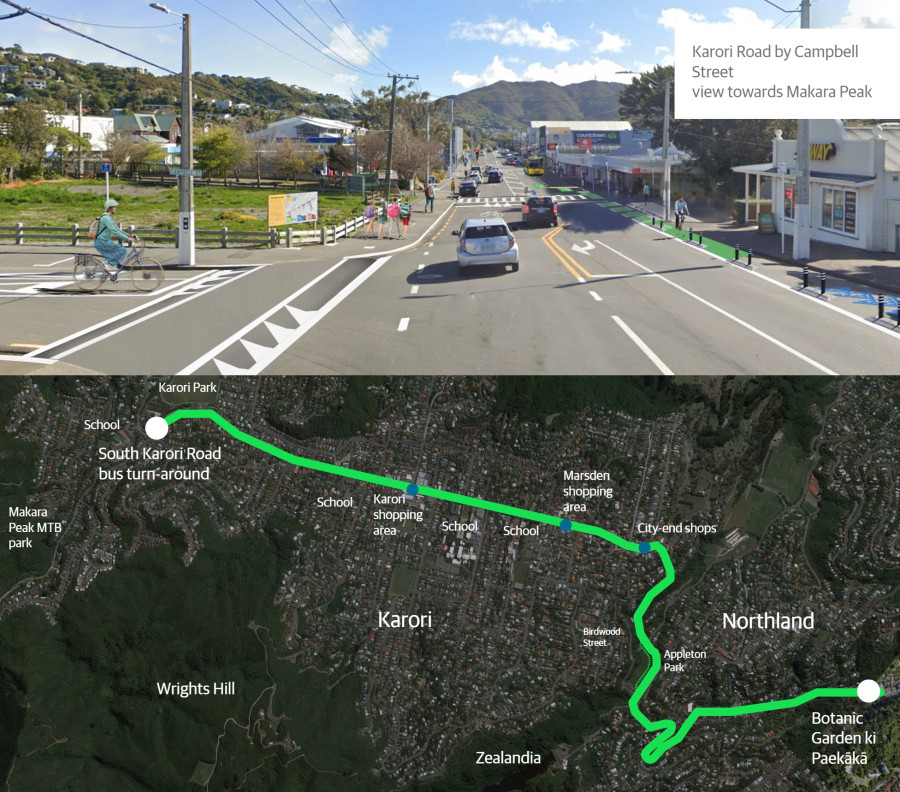
The main bike, bus, and pedestrian improvements start near Karori West Normal School, and follow Karori Road, Chaytor Street and Glenmore Street to the Botanic Garden ki Paekākā. This is the route most buses take, and a direct route to key destinations for most people.
To make it safer and easier to bike in Karori, this project will provide:
- uphill separated bike lanes where bikes hold up traffic
- shared lanes for cars and bikes travelling downhill
- calmer traffic speeds through shopping areas
- installing a new shared path through Appleton Park.
Improvements to make bus travel safer and easier include:
- lengthening bus stops
- providing two in-lane bus stops
- improving bus stop spacing where they are too close together, for more efficient bus journeys.
Improvements for people walking, using mobility aides and pushchairs, will make it safer and easier to get around by:
- raising existing pedestrian crossings
- installing new pedestrian crossings
- installing better kerb ramps
- encouraging calmer traffic speeds in retail areas
- installing a new shared path through Appleton Park.
As well as the main route, we are making smaller changes to create quiet complementary routes along South Karori Road, Friend Street, and Birdwood Street. These changes were consulted on and approved. Work in these areas is underway and will continue for several months.
Changes based on community feedback
Over 50 changes were made to the proposed designs based on community consultation. These changes include:
- providing better kerb access for vehicle passengers, and eight extra carparks including dedicated visitors parking, by moving the carparking from the Botanic Garden side of Glenmore Street to the residential side of the road.
- changing three proposed in-lane bus stops to kerbside bus stops in locations where it is safe to do so
- creating extra parking provisions along the route for residents and businesses
- retaining the right hand turn into Homewood Ave to minimise queues
- improving patient access to Singleton Dental by adding one mobility park and one P5 drop-off/pick-up park
- providing better bus stop spacing by moving the bus stops outside Karori Park to the east by 100m
- giving parents/caregivers more time to pick up and drop off children by changing P10 parks outside Marsden School to P15 parks.
The Process
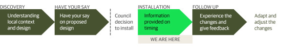
We’ve worked with technical experts and met with key stakeholders and businesses along the affected streets to help inform the changes for this route.
Community feedback and the changes were approved by Councillors on 13 December 2023.
As the bike, bus and pedestrian improvements are installed, we'll gather feedback and data on how the changes are going, so we can improve things such as signs, street markings, and parking.
You can contact us at karoriconnections@wcc.govt.nz if you have any questions.
Our goal is to be a city where people of all ages and abilities can get around safely and easily in climate friendly ways.
Wellington’s population is expected to grow significantly over the coming years. With thousands more people, and at our current rate of car use, our streets will grind to a halt.
That’s why we’re freeing up our streets by making it safer and easier for people on bikes, using buses, and pedestrians.
Karori connections is the local section of the citywide bike network that is being delivered alongside improvements for pedestrians, people scooting, and taking the bus. Karori connections addresses some of the issues raised through the 2017 project, Karori: A Vision for the Future, and the Bus Priority Action Plan 2019.
The bus and pedestrian improvements will be installed using permanent materials, but new bike lanes will be created using adaptable materials. This approach allows bike and scooting improvements to be created quickly, so people can start using the route, and give feedback for future permanent improvements.
This new approach and the full bike network plan, Paneke Pōneke, was consulted on in November 2021, and was approved by Councillors on 10 March 2022.
Karori Connections partners are working together to deliver an integrated transport solution for Karori.
Project partners are:
- Wellington City Council
- Greater Wellington Regional Council
- Waka Kotahi NZ Transport Agency - Climate Emergency Response Fund.
Karori Connections bike improvements are partially funded by the Transport Choices programme. Transport Choices is part of the Government’s Climate Emergency Response Fund, formed out of the Emissions Reduction Plan to make it easier for people to participate in a low carbon transport system.
Wellington is expected to grow over the next 30 years, which will dramatically affect the way our city looks, feels, and operates. If we continue at our current rate of car use, our transport network will grind to a halt.
Our goal is to be a city where people of all ages and abilities can move easily and freely in low-carbon ways. These essential street changes will make it easier for more of us to be less reliant on our cars.
We’re changing our streets to make it safer and easier for people to walk, ride, scoot, or use public transport. The changes we’re developing will take time to get used to, but we need to adapt to make sure we can still get around.
In line with Council strategies, policies, and plans, we have developed Paneke Pōneke, a citywide bike network plan. Changes as part of Paneke Pōneke will happen alongside improvements for people walking, scooting, and taking the bus.
Making it safe and easy to bike, walk, and use public transport for everyday trips is key to rapidly cutting emissions in Wellington. It’s vital that we create a connected network, particularly for beginners and less confident riders, as well as people who are experienced riders, so that more of us can get around more often in low carbon ways.
The following strategies, policies, plans and research provide the context for the development of a safe, connected and high-quality bike network alongside other sustainable transport improvements.
Sustainable transport hierarchy
Our sustainable hierarchy was first adopted in the Urban Growth Plan 2015 (now superseded by the Spatial Plan). The hierarchy prioritises movement by walking, biking, and public transport, so that our city’s streets work better for people.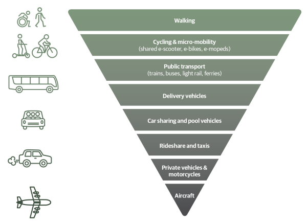
Paneke Pōneke Bike Network Plan 2022
The bike network will connect suburbs to the city centre and destinations, helping to get people of various ages and abilities from where they live to where they work, study, shop, and play. Paneke Pōneke, Wellington’s bike network plan, was adopted in March 2022.
We consulted on the bike network plan between 2 November – 14 December 2021 as part of the Our City Tomorrow engagement. This engagement also included the draft District Plan and options for mass rapid transit routes through Let’s Get Wellington Moving.
Long-term Plan 2021-2031
The Long-term Plan updated the city outcomes and priority objectives. It also provided $226 million over 10 years to develop a bike network. This is supported by investments in Let's Get Wellington Moving, which will provide for safe biking in the city centre and key corridors connecting to the city centre.
Spatial Plan 2021
The Spatial Plan 2021 provides a blueprint for more housing to accommodate a growing population over the next 30 years. This includes supporting tens of thousands more people to live in the inner-city suburbs and within walking distance of the city centre and rapid transport stops.
A well-connected walking and biking network is key to accommodating more people in the city without adding to car congestion or putting pressure on our bus services.
Greater Wellington Regional Council, Wellington Regional Land Transport Plan 2021
This plan sets out the strategic direction for transport investment across the Greater Wellington region, including targets to reduce transport emissions and increase the proportion of people walking, biking, and using public transport.
Wellington Regional Land Transport Plan 2021
Parking Policy 2020
The Parking Policy provides a framework to guide future decision-making on the management of all Council-controlled parking spaces, and how parking supports achieving the vision for Wellington. The Parking Policy refers to the sustainable transport hierarchy, which gives highest priority to active modes of transport, such as walking, biking, and public transport. This means that when we make decisions on using road space, these active modes take a higher priority to parking.
Te Atakura First to Zero Blueprint and Implementation Plan 2019
We aim to become a net zero carbon city by 2050. Road transport emissions represent 34% of our city’s emissions – making them the single biggest source. Electric vehicles alone can’t solve this problem, given their relative expense. Making it safe and easy to bike, walk, and use public transport for everyday trips is key to rapidly cutting emissions in Wellington.
Te Atakura - First to Zero Blueprint and Implementation Plan 2019
Previous cycling strategic documents
- Wellington Cycle Network Strategic Case 2015: This outlines the challenges related to cycling and how achieving the objectives will benefit Wellingtonians.
- Cycling Framework 2015: This set out a decision-making process for the bike network and how it would be developed. It should be noted that design guidelines for what makes a safe bike lane are continually being developed and we expect to take account of current guidance as we plan improvements.
- Cycling Demand Analysis 2014: This research investigated how different types of cycling infrastructure is likely to affect the numbers of people choosing to cycle in Wellington and assessed the demand for improvements.